| | -
-
-
-
-
| |  |
|
1 |
-
-
| |  |
|
1 |
-
-
-
-
-
-
-
-
|
| | |
|
| Hiking | 16.86 Miles |
2,779 AEG |
| | Hiking | 16.86 Miles | 8 Hrs 8 Mns | | 2.19 mph |
| 2,779 ft AEG | 26 Mns Break | | | |
|
|
| |
| Partners |
|
[ show ]
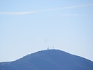
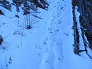
| partners | | | This is the short version of the hike. For full details see adilling's and DarthStiller's trip reports. We started the hike around 7am at the Mt Peeley TH. It was cold. The breeze was cold the shade was cold and I was cold. After about a mile of uphill you started to thaw. The Divide trail was in pretty good shape. There some snow in the shaded sections of trail but safe to cross as long as you were careful. The views on the Divide trail were great. You could see the Superstitions, Four Peaks, Mt Ord, the San Francisco Peaks, Bartlett lake and more. Not much fauna was encountered along the way but the birds were out. We stopped for lunch. It was cold. Y-Bar was easy enough to follow with some overgrowth in areas. The worst part of Y-Bar trail were the rocky sections where you needed to slow down to avoid injury. A nice day out on the trail with Andy & Chris. The best part of the hike was in the sun and out of the wind. |
| _____________________
| | |
|
|
|
|
|
| |
 Route Editor


