| | -
| 4 labels | 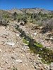 |
|
|
-
-
| 1 label | 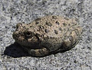 |
|
|
-
-
-
| 1 label | 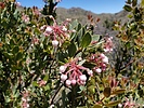 |
|
|
-
| 1 label | 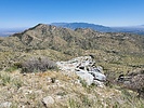 |
|
|
-
-
-
-
-
| 1 label | 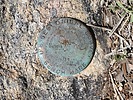 |
|
|
-
| |  |
|
1 |
-
| 1 label | 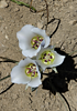 |
|
|
|
| | |
|
| Hiking | 11.22 Miles |
2,692 AEG |
| | Hiking | 11.22 Miles | 8 Hrs | | 1.40 mph |
| 2,692 ft AEG | | | | |
|
|
| |
| Linked |
|
none
[ show ]
| no linked trail guides |
| Partners |
|
none
[ show ]
| no partners | | As others have said in their trip reports, there are three gates on FR677 (and most park at the third gate). I have 4WD with high clearance, but I wasn't liking the deep diagonal and horizontal ruts, so I parked at gate #1 and walked the rest of the way. In hindsight after seeing the road condition to gate #3, I probably could have driven there.
At the end of the road at gate #3, I had a hard time finding the trail. I ended up walking along the creek, which is mostly where the trail goes anyway. I walked it all the way to the section where the trail leaves the creek and heads up the mountain. Well, except for one huge waterfall (maybe 30 feet) that had to be hiked around on the west side. A nice path right there goes up and around it.
When I left the creek, I again had a hard time finding the trail. I lost track of it a few times. Some blood was donated in this area thanks to lots of catclaw  . The trail eventually became easier to see, and was much better starting from below the switchbacks until the saddle at the top of the ridge. A lot of vegetation has grown in the middle of the trail. Several times the growth made the trail appear to just end. And from the creek to the switchbacks, a long distance of the trail is covered in small ankle-rolling rocks. . The trail eventually became easier to see, and was much better starting from below the switchbacks until the saddle at the top of the ridge. A lot of vegetation has grown in the middle of the trail. Several times the growth made the trail appear to just end. And from the creek to the switchbacks, a long distance of the trail is covered in small ankle-rolling rocks.
The trail from the saddle to the summit of Cottonwood Mountain is marked on topo maps as Gardner Canyon Trail #67, but all I could find were occasional cairns. It was a bushwhack to the summit and benchmark, but it was not that bad for a bushwhack. There was even a nice animal path through a big patch of burned manzanita bushes.
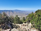
The views were not bad for the majority of the hike before reaching the saddle (except for the burned trees). But once on top and you get to look down the other side to the north and northwest, that's when things really become spectacular! I went over to the edge many times to take photos of the beautiful rock formations and views.
Cottonwood Canyon was flowing, and the frogs were really singing on my way out. Saw one cow by the creek, and later saw two jackrabbits along Klondyke Road (plus lots more cows). I had the whole area to myself for the entire day - no humans seen at all. |
|
Wildflowers Observation Light
Thistle, Verbena, Fleabane, Indian Paintbrush, Sego Lily and a few others. |
|
| _____________________
| | |
|
|
|
|
|
| |
 Route Editor


