| |
 | Sluice Boxes State Park, MT | | -
-
-
-
-
-
-
-
| 1 label |  |
|
|
-
-
-
-
-
-
| 2 labels | 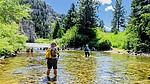 |
|
|
-
|
| | Sluice Boxes State Park, MT | | | |
|
|
Sluice Boxes State Park, MT
| | |
|
| Hiking | 4.45 Miles |
950 AEG |
| | Hiking | 4.45 Miles | 4 Hrs 49 Mns | | 1.55 mph |
| 950 ft AEG | 1 Hour 57 Mns Break | | | |
|
|
| |
| Linked |
|
none
[ show ]
| no linked trail guides |
| Partners |
|
[ show ]
| partners | | Written 9-5-2025. After one of the best breakfast's I have ever had, we headed out east of Great Falls to do this hike that Wendy found on the internet. It was about a 40 minute drive.
It was a lovely morning as we stopped to look over the sign at the entry to the park. There were other vehicles there and we would run into hikers off and on throughout the day; except when I took the upper trail to the other TH. You are in a bit of a canyon sided by limestone cliffs with lots of berry bushes, tall grass and scattered flora as you headed toward the river. It was quite green. They have been getting rain off and on throughout this part of the summer.
This state park is located in the Little Belt Mountains and follows Belt Creek through a limestone canyon. It is known for its rugged terrain, steep cliffs, and the remains of historic mines, a railroad, and cabins. The park offers opportunities for fishing, hiking, and wildlife viewing, although the terrain can be challenging. Hiking is generally restricted to low water seasons.
Our first distraction was some noise by the creek. As we wandered over there we saw a pipe and some ramping among a few other leftovers from the past of this area. After we checked out the people action on the river, we headed back to the main trail. Along this part we would encouter a few groups of people. Most folks seem to just go to the first crossing and turn back. Just before our first river crossing, the trail was surrounded by tall bushes. The crossing area is by an old wrecked car. I would love to know the history.
We rolled up our pant legs and crossed the wide river. There weren't any narrow crossings and the water was running pretty fast. It also got deep in places. This is one time that being tall helps  . Wendy led the way. Not too far from here was the double cabin and delapidated equipment area. We wandered around here for a bit. . Wendy led the way. Not too far from here was the double cabin and delapidated equipment area. We wandered around here for a bit. Sluice Boxes State Park was created in 1974 and included significant historic structures and remnants of the abandoned towns of Riceville and Albright that once existed for the purpose of mining limestone in the canyon.
It was a beautiful valley so it must have been quite the place at one time.
As we made our way to the next crossing, we saw quite the cairn, but it's a good thing it was there as the grass and berry bushes were quite tall and hid the trail to the river crossing. There was remanants (wood posts) of an old bridge. The trail headed toward a forested area. It was nice to have a little shade. We crossed the creek again and it seemed the canyon narrowed a bit here. Our third crossing was a little deeper. Fortunately it wasn't too slippery. At this crossing are the huge cement ruins of a Montana Central Railroad deck plate girder bridge (constructed in 1889-1891).
I told the girls I would wait for them here and they could continue ahead. After being in nap mode for about ten minutes I look up and Wendy is staring at me. She says they came back as I need to continue with them as they were seeing cool stuff. Well so much for soaking it in as they say. We ended hiking up on the railroad bed as there were wood tracks here and there. We started to climb up a bit where we got above the beautiful Belt Creek running next to the tall limestone canyon walls. We saw some pretty good sized alcoves next to the water.
We came across part of the trail that looks like it got run over by a train . Kathy took one side and Wendy the other. I opted for Wendy's choice. Then the trail seemed to seep away into gravel down to the creek. It also got us closer to the alcove. We continued on and they actually had stone steps for us to get back up on the old railroad bed. Not too far from there we saw a couple guys on the other side and someone down on what the map calls Picnic Beach. It looked like they were going to jump so we stayed to watch; looked like fun. A little further along we could see some sort of structures across and above the creek. . Kathy took one side and Wendy the other. I opted for Wendy's choice. Then the trail seemed to seep away into gravel down to the creek. It also got us closer to the alcove. We continued on and they actually had stone steps for us to get back up on the old railroad bed. Not too far from there we saw a couple guys on the other side and someone down on what the map calls Picnic Beach. It looked like they were going to jump so we stayed to watch; looked like fun. A little further along we could see some sort of structures across and above the creek.
As we came to the end of the shaded part, I told the girls to go on and I would wait for them here. As I looked around I could see what looked like a tunnel but I don't think it was. Wish I had zoomed some more. Anyway, we were pretty high above the water along the cliff. That railroad ride must have been something else. They came back in 40 minutes and said they saw some cool stuff. They took a little break for a snack before we headed back.
We all ate our fair share of berries and raspberries as they were pretty abundant. We went down the stairs, climbed back up the cliff, and back up to the railroad bed. Once we got to the first creek crossing, I made sure they got across safely and filmed them, of course. I backtracked a bit to catch the trail that gets to the upper TH. I climbed up about 360 feet in 3/4 of a mile. The trail was very nice and marked well, too. As I got higher I could see where we had hiked. I grabbed some Mullein to test it out for real.
I got to a split in the trail. One side was angling down and all I really wanted to do was go up to get to the road where the other Overlook was. So I went left. The trail, more or less, ran out so I just made my way to the gate in the very taut barbed-wire fence. There was some tall weeds; enough for me to do some business, before finishing my trek. The gate was very hard to close, but I persevered.
I could see the Overlook parking lot below so I headed down the highway to wait for Tonto. I think I could have taken that other trail to get here ](https://hikearizona.com/dex2/images/smilies/eusa_wall.gif "Brick wall") . Oh well. They arrived fairly quickly and we headed for Belt for some libations. Belt is a cute little town and we found a tavern for some beer and then a tavern with food before heading back to Great Falls. (Belt was where my homesteading and other families went to get their coal back in the early 1900s.) . Oh well. They arrived fairly quickly and we headed for Belt for some libations. Belt is a cute little town and we found a tavern for some beer and then a tavern with food before heading back to Great Falls. (Belt was where my homesteading and other families went to get their coal back in the early 1900s.)
Next up: The Sip 'n Dip Lounge is a well-known tiki bar famous for its unique feature of live mermaid performances visible through a glass-walled pool behind the bar.
The bar was full but we were lucky in that a table toward the front was leaving and saved it for us. We enjoyed the show and the Fish Bowl cocktail.
And last, but not least, it was off to Giant Springs: One of the largest freshwater springs in the United States, discharging over 156 million gallons of water daily at a constant temperature of 54°F (12°C).
Roe River: The park is also home to the Roe River, once listed in the Guinness Book of World Records as the world's shortest river, flowing from Giant Springs into the Missouri River.
Videos from the hike (it really was a special area):
Part 1 [ youtube video ]
Part 2 [ youtube video ]
Part 3 [ youtube video ]
and you can't beat The Mermaid and Muskrats [ youtube video ] |
|
Wildflowers Observation Moderate
|
|
| _____________________
For me, sometimes it's just as much about the journey as the destination.
Oh, and once in awhile, don't forget to look back at the trail you've traveled. |
| | |
|
|
|
|
|
| |
 Route Editor


 . Kathy took one side and Wendy the other. I opted for Wendy's choice. Then the trail seemed to seep away into gravel down to the creek. It also got us closer to the alcove. We continued on and they actually had stone steps for us to get back up on the old railroad bed. Not too far from there we saw a couple guys on the other side and someone down on what the map calls Picnic Beach. It looked like they were going to jump so we stayed to watch; looked like fun. A little further along we could see some sort of structures across and above the creek.

