| | -
-
-
-
-
| |  |
|
1 |
-
| 2 labels |  |
|
|
-
-
-
-
-
-
-
-
|
| | |
|
| Hiking | 10.50 Miles |
1,596 AEG |
| | Hiking | 10.50 Miles | 4 Hrs 30 Mns | | 2.33 mph |
| 1,596 ft AEG | | | | |
|
|
| |
| Linked |
|
none
[ show ]
| no linked trail guides |
| Partners |
|
none
[ show ]
| no partners | | In March 2007, I was looking around on the internet for new hikes, and I came
across the tantalizingly named Baby Jesus Ridge Trail in the Catalinas. The trail
description I got was from a mountain biking website, and I did a little scouting
via Google Earth. There is a loop that connects the 50-Year Trail with the Baby
Jesus, Sutherland, Link Trail, and back to the 50-Year. I set out to do this loop in
2007 and it was a spectacular failure. I had read that the Baby Jesus Trail would
be overgrown, so I didn't think twice when I began going up the ridge, fighting all
sorts of catclaw and mesquite. I will never forget the moment I realized that I was
way off track and that my planned loop was never going to happen. Then, as I
was backtracking towards my car, it started to rain and the sun set on my little
adventure. I ended up having to hike for a couple of hours in the rain and dark,
navigating by the GPS that my husband had thankfully gotten for me when I
started hiking solo. I was still a novice at working my GPS and it had no base
maps on it, otherwise I would have realized a lot earlier that I was not going the
way I thought I was. I had cell reception in this area and was able to call my
husband and tell him that I was okay, but I was going to be home a lot later than I
thought. It all worked out in the end, but not before I was completely freaked out
by a glowing pair of eyes that I saw under a tree on my way back to the car.
So, with that backstory, it was with a tiny bit of trepidation that I attempted this
same loop this week. Between the first hike and this one, I had found my way
800 miles across Arizona on the sometimes-hard-to-find Arizona Trail. Could the
Baby Jesus be that difficult? How would I fare on my return to the Baby Jesus
Loop? Besides, this time I was armed with a GPS and I knew how to use it...
The forecast was for a high of 67- perfect hiking weather under blue skies dotted
with fluffy white clouds. I started out off of Golder Ranch Road (the same place
as my blog entry from 11-24) and hiked the familiar 50-Year Trail to FR 642 to
the junction in the circular wash with the cottonwoods. There are several paths in
this area and you have to pick the path with a carsonite post that says
"restoration area" with a brown metal step-over gate in the fence. This is, I
believe where I made my mistake on the previous hike. Because once I passed
the fenceline, the Baby Jesus Ridge Trail was in perfect shape. It even looked
like someone had pruned it back recently. As I was hiking this clear, easy-to-
follow trail, I couldn"t believe it. I kept thinking, "I was never on the Baby Jesus,
that's why I couldn't complete the loop!" Wow. That was a humbling moment. The
trail follows a lower ridge that is a little bit farther east and behind the main ridge
that you can see at the trailhead. I think I went up the larger ridge on my previous
visit. After my initial shock wore off, I was able to fully enjoy what the Baby Jesus
has to offer. Beautiful views of Samaniego Ridge and Samaniego Peak dusted
with snow. There were great piles of bouldery formations, and -surprise- clear
trail. There were some foot, horse, and bike prints, and it looks like it gets a
decent bit of use. There is a big field of behemoth saguaros that the trail winds
through near the beginning.
I could look north and see my route that I took on last week's backpacking trip
through Sutherland Gap and the Biosphere in the distance. My favorite part of
the whole loop was when I got close to Wooden Trough Spring, almost 3 miles
into the Baby Jesus Trail. This was all new to me, and I really liked the peaks on
the ridge that forms Cargodera Canyon. Great peaks with sheer cliffsides. I
reached the spring, which is right on the trail, and was surprised to find a healthy-
looking population of showy orange and black goldfish living in the clear water.
One of the orange fish was as big as my hand! The area near the spring would
make a great camp spot, and I filed it away in my "places to come back and
spend the night" file. From the spring to the Sutherland junction, the trail was
slightly more overgrown, but mostly at ankle-level.
I reached Flat Rock Meadow, a wash crossing with- you guessed it- flat rocks. I
knew that the Sutherland Trail junction couldn't be far away, so I passed up this
spot and continued on to the next scenic place to stop and eat lunch. The Baby
Jesus Ridge Tr. is about 4 miles long, but not marked with any kind of sign at
either end. I reached the Sutherland junction, at a large cairn on a powerline
road. Shortly afterward, I found a beautiful spot for lunch on a rock outcrop
overlooking the changing sycamores and cottonwoods in Cargodera Canyon. I
have not hiked the Sutherland Trail at all, and this small peek makes me very
interested. The Sutherland Trail can be followed all the way up to the top of
Mount Lemmon. Of course, the way I would hike it is to get dropped off at the top
and hike down rather than up the 6000 feet elevation gain.
But for today, I was only following the Sutherland Trail, at this point a rocky road,
for one mile before continuing to the Link trail that would take me back to the 50-
Year trail. The Link "trail" is actually a very rocky road. I was glad to be going
downhill. I think that is the reason that most writeups have this loop going
clockwise. Much better to gain elevation on singletrack and lose it on a rough
road. The Link Trail headed into Sutherland Wash and through a gate, well-
signed the whole way. After 2.2 miles, I reached the 50-Year Jct. and turned
north, glad to be back on singletrack after the rocky and sandy jeep road.
This part of the 50-Year is not as interesting as the northern part that goes
through the boulders, but it got me back to my car in no time flat. From the time I
was approaching Sutherland Wash, I kept hearing someone firing a gun, over
and over and over again. The trail would look like it was going toward the sound,
and then thankfully veer away at the last minute. I saw some cars parked on the
jeep road, but never saw the people that were out shooting.
Total time for this 10.5 mile hike was 4.5 hours. I really enjoyed this loop- the first
half is more interesting than the second half, but the whole thing has great views.
I will definitely be back to the Baby Jesus to camp out, but I will be waiting until it
warms up a little bit. There are petroglyphs in this area, and I will be returning to
this area next week to check them out. I will be sure to post pictures!
Read this with full set of pictures here: http://wp.me/pFUf6-F |
|
Autumn Foliage Observation Isolated
|
|
  |
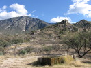
Wooden Trough Spring |
Dripping |
Dripping |
| | | Trough was full and holds a healthy population of orange and black fish | | _____________________
| | |
|
|
|
|
|
| |
 Route Editor


