Wikipedia wrote:The Apache Trail in Arizona was a stagecoach trail that ran through the Superstition Mountains. It was named the Apache Trail after the Apache Indians who originally used this trail to move through the Superstition Mountains.
The current Apache Trail links Apache Junction (33.4152°N 111.5807°W) at the edge of the Greater Phoenix area with Theodore Roosevelt Lake (33.6725°N 111.1531°W), through the Superstition Mountains and the Tonto National Forest.
Today, the majority of Apache Trail remains unpaved, turning into a dirt road a few miles up from Tortilla Flat, and continuing as such for nearly the full remainder of its length. The section east of Apache Junction is known officially as State Route 88. It is also the main traffic corridor through Apache Junction, turning into Main Street as the road passes into Mesa, and regains the Apache name by becoming Apache Boulevard in Tempe, ending at Mill Avenue. Prior to the completion of the Superstition Freeway in 1992, the Apache Junction portion of the Apache Trail was part of US Highway 60, which was rerouted to the Superstition Freeway once it was completed.
The Trail winds steeply through 40 miles (64 km) of rugged desert mountains, past deep reservoir lakes like Canyon Lake and Apache Lake. The narrow, winding road is unpaved from just east of the town of Tortilla Flat to Roosevelt Dam; there are steep cliff drops and little in the way of safety barriers. The trail requires caution when driving and it is not recommended for large RVs, SUVs, or caravans. Some large RV rental companies in the US do not allow their vehicles to be taken on this route.
The Apache Trail will be closed for some major road repairs from November 15 - January 21, 2011. major delays will occur prior to and after those stated dates. Plan your outings accordingly.
State Route 88 will close for six hours on Tuesday, Dec. 12, near Tortilla Flat to allow the Arizona Department of Transportation to remove a boulder from an adjacent cliff.
SR 88 will be closed in both directions between the Laguna Recreation Site (milepost 212) and Tortilla Flat (milepost 213) from 9 a.m. to 3 p.m. Tuesday.
Alternate routes include SR 87 through Payson and US 60 through Globe.
Drivers will be able to access the Canyon Lake marina during the closure.
"The censorship method ... is that of handing the job over to some frail and erring mortal man, and making him omnipotent on the assumption that his official status will make him infallible and omniscient."
George Bernard Shaw
The work will begin with the removal of old pavement along SR 88 in the Canyon Lake Marina and Tortilla Flat areas from midnight to 9 a.m. Monday followed by paving from 9 a.m. to 5 p.m. Tuesday, Feb. 27, and Wednesday, Feb. 28, according to the Arizona Department of Transportation.
Flagging crews and a pilot vehicle will be used to guide traffic through the work zone one direction at a time. A 10-foot vehicle-width restriction will be in place in the work zone.
The milling operation to remove old pavement will resume from midnight to 9 a.m. Friday, March 2. Crews then plan to pave during daytime hours Monday through Thursday until late March. Milling work is scheduled for early morning hours on Fridays as crews continue working along SR 88 between mileposts 202 and 213.
"The censorship method ... is that of handing the job over to some frail and erring mortal man, and making him omnipotent on the assumption that his official status will make him infallible and omniscient."
George Bernard Shaw
A stretch of State Route 88, also known as the Apache Trail, will be closed near Tortilla Flat northeast of Apache Junction on Tuesday and Wednesday mornings (June 12-13) for rock-removal work. Drivers should delay travel or use alternate routes while the closures are in place.
"The censorship method ... is that of handing the job over to some frail and erring mortal man, and making him omnipotent on the assumption that his official status will make him infallible and omniscient."
George Bernard Shaw
I drove Apache Trail, State Route 88 yesterday afternoon late and the re-paving is now complete all the way to Tortilla Flat. This includes the paint stripping, expanded pullouts, signage and a new concrete surface on the crossing of Tortilla creek. The drive was wonderful and a joy to experience and see. Beyond Tortilla the roadway is still as it was but they have been installing additional guard rails and improving the old. Give them another three or four months and all will be completed. The gravel road to the bottom of Fish Creek Hill is the same and the roadway down Fish Creek Hill is in need of new gravel and grading.
A man's body may grow old, but inside his spirit can still be as young and restless as ever.
- Garth McCann from the movie Second Hand Lions
PHOENIX – State Route 88 has reopened between milepost 204, east of Apache Junction, and milepost 213, Tortilla Flat, according to the Arizona Department of Transportation.
The highway remains closed between milepost 213 and the State Route 188 junction due to flooding and cleanup work. There is no estimated time to reopen the remaining section of highway.
I talked with a hydrologist from SRP and one of my friends with the Forest Service over the weekend and both are saying that the road may not be open for at least a year and could go longer depending on funds for repair. An interactive map on ADOT's home page has the Apache Trail closed at both ends. There is a steel gate at the Tortilla Flat creek crossing with a combination lock to prevent cars/trucks from going further on the road. Louie at the Bluebird told me that there's a lot of heavy truck traffic on the road mostly hauling dirt for road repair.
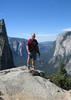
On every trip into the Superstitions, I find another Gold Mine. Today the mine was filled with Memories. I can not wait for the next trip.
If I were a betting man, I would put my money on ADOT working on the east side repairs to make access to Apache Lake possible from Roosevelt.
I fear that Fish Creek Hill, on the other hand, may never open. Clearing the road from the landslide is no big deal. But stabilizing the hillside above the roadway so that it doesn't happen again ... that may be a feat of engineering that the budget can't justify for what is essentially nothing more than a scenic drive. It will be interesting ...
I'm not sure what my spirit animal is, but I'm confident it has rabies.
@chumley
I had similar thoughts after seeing the drone footage that ADOT put up. Clearing flood-deposited debris off the road is one thing, making Fish Hill safe, where the road traverses essentially a talus slope, is a much bigger challenge.
Shawn
The bear went over the mountain to see what he could see.
chumley wrote:I fear that Fish Creek Hill, on the other hand, may never open. Clearing the road from the landslide is no big deal. But stabilizing the hillside above the roadway so that it doesn't happen again ... that may be a feat of engineering that the budget can't justify for what is essentially nothing more than a scenic drive. It will be interesting ...
That's a big concern among the businesses along the Apache Trail, they're already putting a petition together to address the need for the road and the traffic that supports those businesses.
On every trip into the Superstitions, I find another Gold Mine. Today the mine was filled with Memories. I can not wait for the next trip.
That's a big concern among the businesses along the Apache Trail, they're already putting a petition together to address the need for the road and the traffic that supports those businesses
Apache Lake Marina announced on social media today that they are selling the resort and cited the loss of revenue from the Woodbury Fire as the reason. They said serious buyers only, whatever that means. I am thinking HAZ timeshare maybe...
If they ever do attempt to rebuild on Fish Creek Hill, I hope they make it wider. I can live with a narrow stretch of road, but that works better when drivers in opposing traffic are accustomed to narrow roads.
Lifeis not a journey to the grave with the intention of arriving safely in a pretty & well preserved body, but rather to skid in broadside, totally worn out & proclaiming,"Wow What a Ride!"
 Route Editor