 Route Editor

Hellsgate
Moderators: HAZ Group Coordinators, HAZ - Moderators
Linked Guides none
-
 decarloGuides: 1 | Official Routes: 0Triplogs Last: 8,803 d | RS: 0Water Reports 1Y: 0 | Last: never
 - Joined: Apr 29 2002 10:43 pm
- City, State: Fountain Hills, AZ
Hellsgate
Why is Hellsgate trail not in the trailDex. It's in Payson... about 11 miles long passing through a canyon. I am hiking it this weekend. In on Saturday and out on Sunday. Anyone interested in going? Does anyone know this trail... are there any good views?
Neil DeCarlo
decarlo@cox.net
decarlo@cox.net
contribute to this member driven resource
ie: RS > Save/Share after hikes 

-
 Snick33Guides: 0 | Official Routes: 0Triplogs Last: 8,760 d | RS: 0Water Reports 1Y: 0 | Last: never
 - Joined: Feb 03 2002 10:18 am
- City, State: Scottsdale, AZ
Hellsgate in Payson
There are lots of trails not listed in the Trail DEX. I've done the hike and it's a good one. This would be a great place for you to start as a contributor to the TrailDEX, be sure to take along a camera.
Last edited by joebartels on Apr 27 2017 2:33 pm, edited 1 time in total.
Reason: dead link removed
Reason: dead link removed
Mother nature seems to like humans, and not just because they taste like chicken
contribute to this member driven resource
ie: RS > Save/Share after hikes
-
decarloGuides: 1 | Official Routes: 0Triplogs Last: 8,803 d | RS: 0Water Reports 1Y: 0 | Last: never
- Joined: Apr 29 2002 10:43 pm
- City, State: Fountain Hills, AZ
Hellsgate
Much thanks Snick. Can I use one of those cheap disposable cameras? Then I suppose I'd have to get the photos scanned in jpeg? Are their any good views on this trail... is it wooded? NDC
Neil DeCarlo
decarlo@cox.net
decarlo@cox.net
contribute to this member driven resource
ie: RS > Save/Share after hikes
-
Snick33Guides: 0 | Official Routes: 0Triplogs Last: 8,760 d | RS: 0Water Reports 1Y: 0 | Last: never
- Joined: Feb 03 2002 10:18 am
- City, State: Scottsdale, AZ
Hellsgate
There aren't many trees to see but lots of Riparian sections. As for views, I honestly have never hiked anywhere in Arizona where the view didn't take my breath away at some point.
I'm a big believer in disposable cameras, and even though I have a Sony digital camera I always carried a disposable in my pack. You can get a hell of a digital these days for under a hundred bucks and it does make life a lot easier.
I've got trail descriptions started for several hikes but although I consider a decent writer I've found it harder than expected to acurately describe a hike. Try reading some of the TrailDEX's, it has helped me a bunch.
Enjoy your hike.
Mother nature seems to like humans, and not just because they taste like chicken
contribute to this member driven resource
ie: RS > Save/Share after hikes
-
decarloGuides: 1 | Official Routes: 0Triplogs Last: 8,803 d | RS: 0Water Reports 1Y: 0 | Last: never
- Joined: Apr 29 2002 10:43 pm
- City, State: Fountain Hills, AZ
Once again Snick, thanks for your views. I am a writer by trade, so it shouldn't be too hard to describe the journey - although I tend to be very lazy with my words when not writing my usual business books. When you write for a living, your main objective in your free time is to NOT WRITE. I imagine that's where the camera would help. Can you really get a good digital under $100 bucks? What would you recommend, and where can I see the pictures you have taken with this cheap gem? Neil
Neil DeCarlo
decarlo@cox.net
decarlo@cox.net
contribute to this member driven resource
ie: RS > Save/Share after hikes
-
Snick33Guides: 0 | Official Routes: 0Triplogs Last: 8,760 d | RS: 0Water Reports 1Y: 0 | Last: never
- Joined: Feb 03 2002 10:18 am
- City, State: Scottsdale, AZ
Hey Cakewalk!!!
Post some of your pictures taken with the D-Link camera so we can see the quality.[/img]
Mother nature seems to like humans, and not just because they taste like chicken
contribute to this member driven resource
ie: RS > Save/Share after hikes
-
 joebartelsGuides: 264 | Official Routes: 224Triplogs Last: 2 d | RS: 2064Water Reports 1Y: 28 | Last: 12 d
 - Joined: Nov 20 1996 12:00 pm
Cakewalk... look closely at snicks post above - it's for YOU! :P
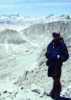
decarlo - Take advantage of snicks link above to the Verelys masterpiece. You can easily judge the vegetation with that one photo overlooking the canyon.
It's not gonna be Yoggie Bear forest if that's what you're looking for, nevertheless I think it's a great area. 'See Canyon' going up the rim instead of away from the rim has the thick, tall coverage. But it's a short go. Christopher Creek dumps into the mid-upper of Tonto. Also, Tonto Narrows is featured on site with views of the sw-lower Hellsgate Wilderness.
For an idea of the area lookup...
Christopher Creek Gorge
See Canyon
Drew Trail
Horton Creek
Tonto Narrows
here's a gift
http://hikearizona.com/t2002/pay/pysnhllgt.JPG
--- for cameras you can most definitely get an excellent digital these days under $250. Anything over 2.3 megapixels is more than the average snapshot guy needs. A $100 is probably plenty for basic shots, just don't go under 1 megapixel
Anything higher price gets into lenses, speed & functions. Most wouldn't understand it unless they're into photography.
- joe
contribute to this member driven resource
ie: RS > Save/Share after hikes
-
 LizardGuides: 15 | Official Routes: 0Triplogs Last: 5,499 d | RS: 0Water Reports 1Y: 0 | Last: never
 - Joined: Feb 05 2002 6:40 pm
- City, State: Phoenix, AZ
You can get cheap digitals that will take decent photos. For example I took this photo with a free camera that came with a signup for Mindspring.
http://www.photoloft.com/view/Image.asp ... &i=8143995
If I had bought the camera in a store it would have been $40 or less. However, if you're going to buy a digicam I would invest the extra money to get a nice one. For $200 you can get a great camera with good features like an LCD preview screen, zoom, a timer, etc. The camera that took the photo above just took photos, that's it. No timer, not even a flash. I'd invest the extra money personally.
Lizard
"Of course we weren't lost. We were merely where we shouldn't have been, without knowing exactly where that was."
contribute to this member driven resource
ie: RS > Save/Share after hikes
-
 genuinefaithGuides: 0 | Official Routes: 0Triplogs Last: none | RS: 0Water Reports 1Y: 0 | Last: never
 - Joined: Jul 10 2015 8:16 am
- City, State: phoenix, az
Re: Hellsgate
Hello,I am not sure where the best place to post this is about hells gate- but I feel that IT is really really important as some people can get into a lot of trouble because of it. on a search through google- hellsgate this is one of the first to pull up- (not this thread but the one posted about it- on top in bold it says a one nigher-
The hellsgate canyon trail actually goes all the way to GISELA- 37 DOESNT BUT MANY PEOPLE HIKE ALL THE WAY THROUGH- I BY THE GRACE OF GOD WAS ONE OF THEM.
https://www.youtube.com/watch?v=6mAI1s-aTxA is the link of a video that is first to come up as well.
I was not leading the trip but I had heard of others who had done it - saw the video above and also looked at your post. there is a lot of info on the site - but I was just looking for brief reference point. We even spoke with the Forrest service in Payson before we set out to calm our worries of flash flooding in the canyon.
while looking up lots of info the trouble that we got into is severely underestimating the length of the trip. Point being at day 2.5 when we all ran out of food we were all kicking ourselves for not bringing more that was in the car. I wish your opening paragraph said in it "a one day trip i did down to tonto creek and back up"
while finally on the road after our journey we were thankful to be picked up by someone who lived in gizella. They said that many many people come out of that place in a lot of trouble- experienced hikers- even a group of firefighters that got lost etc.
your post is great and I am so thankful for it- and wish i read more of it. I have never in my life been on such an adventure as the one i was on- and it was beautiful- but I got my but totally kicked- mainly because we simply underestimated the time of the journey.
contribute to this member driven resource
ie: RS > Save/Share after hikes
-
 toddakGuides: 13 | Official Routes: 7Triplogs Last: 2 d | RS: 0Water Reports 1Y: 0 | Last: 1,719 d
 - Joined: Nov 15 2005 8:46 pm
- City, State: Jackson, CA
Re: Hellsgate
Glad you enjoyed this awesome place! It can be a bit confusing, since Hellsgate Trail #37 is only the access trail getting you to Tonto Creek, but the canyoneering route down the creek is logged under the description for Tonto Creek [ description ]. It's best to read as many of the past triplogs as possible and try to get a feel for the range of times people take to complete the route, then factor in your own experience, fitness etc. You should also post your own triplog, it will be a help to others. Welcome to HAZ!
contribute to this member driven resource
ie: RS > Save/Share after hikes
-
 hikeazGuides: 6 | Official Routes: 0Triplogs Last: 1,238 d | RS: 0Water Reports 1Y: 0 | Last: 1,238 d
 - Joined: May 13 2002 10:07 am
- City, State: Tempe, AZ
- Contact:
Re: Hellsgate
Glad it all ended well!! What's that saying..? Something like... Experience is what you get when you didn't get what you wanted.genuinefaith wrote:Hello,I am not sure where the best place to post this is about hells gate- but I feel that IT is really really important as some people can get into a lot of trouble because of it. on a search through google- hellsgate this is one of the first to pull up- (not this thread but the one posted about it- on top in bold it says a one nigher-
The hellsgate canyon trail actually goes all the way to GISELA- 37 DOESNT BUT MANY PEOPLE HIKE ALL THE WAY THROUGH- I BY THE GRACE OF GOD WAS ONE OF THEM.
https://www.youtube.com/watch?v=6mAI1s-aTxA is the link of a video that is first to come up as well.
I was not leading the trip but I had heard of others who had done it - saw the video above and also looked at your post. there is a lot of info on the site - but I was just looking for brief reference point. We even spoke with the Forrest service in Payson before we set out to calm our worries of flash flooding in the canyon.
While looking up lots of info the trouble that we got into is severely underestimating the length of the trip. Point being at day 2.5 when we all ran out of food we were all kicking ourselves for not bringing more that was in the car. I wish your opening paragraph said in it "a one day trip i did down to tonto creek and back up"
while finally on the road after our journey we were thankful to be picked up by someone who lived in gizella. They said that many many people come out of that place in a lot of trouble- experienced hikers- even a group of firefighters that got lost etc.
your post is great and I am so thankful for it- and wish i read more of it. I have never in my life been on such an adventure as the one i was on- and it was beautiful- but I got my but totally kicked- mainly because we simply underestimated the time of the journey.
From the 'Tonto Creek hike description http://hikearizona.com/decoder.php?ZTN=587
"This is a very challenging trip. Though we did it in only three days (two nights) from the Hells Gate T/H to Gisela, it is probably best to plan more time to get through. (We barely made it out on the third day after 11 hours of almost solid walking/clamoring/swimming)". (read the Tonto description that refers to the average mph being <1 through some sections).
The exertion plus your body using additional calories to ward off hypothermia can really deplete what seems like 'more than enough' food. Speaking of food deficiencies...On that Tonto trip when I came across P. Fredricks on that last day about noon he was out of food and was down to eating powdered coffee creamer (I guess that's technically 'food', but still)! I can still vividly see him in my mind's eye with a white, powdery ring around his mouth. (Think Tony Montana)
"The censorship method ... is that of handing the job over to some frail and erring mortal man, and making him omnipotent on the assumption that his official status will make him infallible and omniscient."
George Bernard Shaw
George Bernard Shaw
contribute to this member driven resource
ie: RS > Save/Share after hikes