 Route Editor

I know the main TH access to the Tonto Narrows is now closed. We are looking for some alternate routes to get back there for a dayhike. Anyone know of a good TH or access point to hike back there now?
Thanks!
Admin edit: use this route
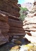
Tonto Narrows Access
Moderator: HAZ - Moderators
Linked Area, etc none
-
 mcopleaGuides: 0 | Official Routes: 0Triplogs Last: 6,320 d | RS: 0Water Reports 1Y: 0 | Last: 6,327 d
 - Joined: May 18 2008 9:47 pm
- City, State: Chandler, AZ
contribute to this member driven resource
ie: RS > Save/Share after hikes 

-
 joshvk121Guides: 0 | Official Routes: 0Triplogs Last: none | RS: 0Water Reports 1Y: 0 | Last: never
 - Joined: Jul 05 2009 1:18 pm
- City, State: mesa
Re: Tonto Narrows Access
How was your trip... Did you find a way back there?sarichter wrote:joshvk121 wrote:Good let me know if you can park there.. someone said that road was boulderd off.
i thought they meant the one that keeps going on the north side of the creek was bouldered off... if so, there are some trailheads just south of that fork, so i plan on driving back and finding a safe parking space there. i'm determined to find a route!
contribute to this member driven resource
ie: RS > Save/Share after hikes
-
 joebartelsGuides: 264 | Official Routes: 224Triplogs Last: 2 d | RS: 2064Water Reports 1Y: 28 | Last: 12 d
 - Joined: Nov 20 1996 12:00 pm
Re: Tonto Narrows Access
sarichter posted his triplog yesterday
http://hikearizona.com/TLOGS_JUMP.php?ID=44667
then view his photos
http://hikearizona.com/TLOGS_JUMP.php?ID=44667
then view his photos
- joe
contribute to this member driven resource
ie: RS > Save/Share after hikes
-
 sarichterGuides: 0 | Official Routes: 0Triplogs Last: 6,038 d | RS: 0Water Reports 1Y: 0 | Last: never
 - Joined: Dec 25 2008 6:16 pm
- City, State: phoenix, az
Re: Tonto Narrows Access
yeah, it was a pain! never made it and i scoured the town looking for access. too much of it is fenced off for grazing or private property. your best bet is to come from the south or houston creek [per Joe]. the houston creek is only useful from Payson... the FS roads get a bit gnarly the farther north you get up sand wash.joshvk121 wrote:How was your trip... Did you find a way back there?sarichter wrote:joshvk121 wrote:Good let me know if you can park there.. someone said that road was boulderd off.
i thought they meant the one that keeps going on the north side of the creek was bouldered off... if so, there are some trailheads just south of that fork, so i plan on driving back and finding a safe parking space there. i'm determined to find a route!
contribute to this member driven resource
ie: RS > Save/Share after hikes
-
 azdesertfatherGuides: 16 | Official Routes: 21Triplogs Last: 4 d | RS: 18Water Reports 1Y: 2 | Last: 327 d
 - Joined: Apr 30 2008 9:57 am
- City, State: Tucson, AZ
- Contact:
Re: Tonto Narrows Access
I noticed an AHOTE group is going out there this weekend, and are planning to make it in thru Houston Creek...if any of you from that group wouldn't mind sharing with us what you found, that would be great!
"I went to the woods because I wished to live deliberately, to front only the essential facts of life, and see if I could not learn what it had to teach, and not, when I came to die, discover that I had not lived." — Henry David Thoreau
contribute to this member driven resource
ie: RS > Save/Share after hikes
-
joshvk121Guides: 0 | Official Routes: 0Triplogs Last: none | RS: 0Water Reports 1Y: 0 | Last: never
- Joined: Jul 05 2009 1:18 pm
- City, State: mesa
Re: Tonto Narrows Access
In response to sarichter:
Hey so the route you posted did u actually try going that way... If i were to get dropped off at the road you posted as the trail you were going to take would i be able to hike down there without having to climb fences...
Hey so the route you posted did u actually try going that way... If i were to get dropped off at the road you posted as the trail you were going to take would i be able to hike down there without having to climb fences...
contribute to this member driven resource
ie: RS > Save/Share after hikes
-
sarichterGuides: 0 | Official Routes: 0Triplogs Last: 6,038 d | RS: 0Water Reports 1Y: 0 | Last: never
- Joined: Dec 25 2008 6:16 pm
- City, State: phoenix, az
Re: Tonto Narrows Access
yeah you can't go that way. it's private property... and i wouldn't suggest climbing fences. you might anger someone or get trampled by cattle...joshvk121 wrote:In response to sarichter:
Hey so the route you posted did u actually try going that way... If i were to get dropped off at the road you posted as the trail you were going to take would i be able to hike down there without having to climb fences...
take the longer route from the south to avoid the town altogether... much easier and everyone will be a lot happier.
contribute to this member driven resource
ie: RS > Save/Share after hikes
-
joshvk121Guides: 0 | Official Routes: 0Triplogs Last: none | RS: 0Water Reports 1Y: 0 | Last: never
- Joined: Jul 05 2009 1:18 pm
- City, State: mesa
Re: Tonto Narrows Access
what i dont understand is on the topo map it only shows a small portion of that road is on private property.. and its past the creek .. so did you run into a private property sign before the creek... if so let me know so i can call the payson ranger station and ask them y there topo map shows no priate property until a certin point yet there is sign that says private property when clearly on there topo map it is not.
contribute to this member driven resource
ie: RS > Save/Share after hikes
-
joshvk121Guides: 0 | Official Routes: 0Triplogs Last: none | RS: 0Water Reports 1Y: 0 | Last: never
- Joined: Jul 05 2009 1:18 pm
- City, State: mesa
Re: Tonto Narrows Access
personally i dont care what the town people of gisela think... im out to hike ... not to break into peoples houses, which is the reason they closed down the trail.. apperntley the 4 house on the private property were getting broke into and the insurance company told them they would drop there coverage if they didnt close down the trail.. so stupid.. its probably people from thier own town causing the trouble... i understand private prop means pivate prop.. but if there just throwing up signs where ever they feel and its not really private prop then i have a big problem with this... im just a hiker and a fisherman.. i really want to fish in the narrows.. my brother caught a 5 pound small mouth bass there last year.. i am going to get to the bottom of this .. any info you have would be great ... thanks alot ..
contribute to this member driven resource
ie: RS > Save/Share after hikes
-
sarichterGuides: 0 | Official Routes: 0Triplogs Last: 6,038 d | RS: 0Water Reports 1Y: 0 | Last: never
- Joined: Dec 25 2008 6:16 pm
- City, State: phoenix, az
Re: Tonto Narrows Access
there are signs that say private property and no trespassing with stated ARS numbers... so yes, it's private property. to what extents it stops, i do not know... but there is fencing up to prevent you from traveling futher, so cutting across the town is a no-no. like i said previously... start from the south end near rye creek road or from payson down houston creek and you will make the narrows with no problems.
contribute to this member driven resource
ie: RS > Save/Share after hikes
-
 AHOTEGuides: 0 | Official Routes: 0Triplogs Last: 5,293 d | RS: 0Water Reports 1Y: 0 | Last: never
 - Joined: Nov 05 2006 5:53 pm
- City, State: Chandler, AZ
- Contact:
Re: Tonto Narrows Access
I am going up this Saturday to find a new way in. Probably off FR 371, through Houston Creek. I talked to the owner of the property and he said you can go around the property up the ridge to the north of the Gisela road. It is very brushy and once you get around the property you would need to rappel into Houston Creek. Getting back would obviously be an issue.
Also, the trailhead was closed down January 1st because the residence are the ones who would go in and clean up the area after the drunk a-holes finish trashing the place. At one point last year there were 60 vehicles (yes, they counted) blocking the road and they ask the people to please not trash the place and they got beer bottles thrown at them. They also had to put up with drunk driving and accidents all along that road. Unfortunately the unruly crowd ruined it for everyone.
I will post how it went next week.
contribute to this member driven resource
ie: RS > Save/Share after hikes
-
sarichterGuides: 0 | Official Routes: 0Triplogs Last: 6,038 d | RS: 0Water Reports 1Y: 0 | Last: never
- Joined: Dec 25 2008 6:16 pm
- City, State: phoenix, az
Re: Tonto Narrows Access
yeah, i walked that way... for quite some time... it's quite bushy and i got quite bored. the property fence goes quite a long way north... as for the rappelling... never made it that far. glad i didn't because i would've been even more disappointed!
contribute to this member driven resource
ie: RS > Save/Share after hikes
-
AHOTEGuides: 0 | Official Routes: 0Triplogs Last: 5,293 d | RS: 0Water Reports 1Y: 0 | Last: never
- Joined: Nov 05 2006 5:53 pm
- City, State: Chandler, AZ
- Contact:
Re: Tonto Narrows Access
We went out looking for a new route into Tonto Narrows. We took FR 371 for 10+ miles to the end. A high clearance vehicle is needed, four wheel drive if it has rained. At the end of the road we parked and descended south on a quad trail. Stick to the top of the ridge once the quad road ends near the bottom of the saddle. From here you will bushwack until you get to the creek. Continue up the hill in front of you and down the other side to Houston Creek. Watch for wasp nest in the ground. We stepped on one and had three people get stung 6-7 times each. Houston creek has water in it. Similar to Aravaipa only not as wide. Parts of the creek reminded me of Salome Jug with the smooth, pink granite. You will continue in the creek for almost 6 miles to Tonto creek. Unfortunately, you will now be too tired to enjoy the Narrows. I would not recommend this trip for anyone who has not done canyoneering before. Half our group turned around at 5 miles and three people continued through to Gisela and hiked out to the 87 where we picked them up. Only two of us made it to Tonto creek and back up for a distance of 12.5 miles. We didn't even go to the Narrows.
contribute to this member driven resource
ie: RS > Save/Share after hikes
-
sarichterGuides: 0 | Official Routes: 0Triplogs Last: 6,038 d | RS: 0Water Reports 1Y: 0 | Last: never
- Joined: Dec 25 2008 6:16 pm
- City, State: phoenix, az
Re: Tonto Narrows Access
nice description and definitely thanks for the effort. i was afraid it would be quite a haul myself and i stopped to prevent any more pain that i had already received with my stupid sandalsAHOTE wrote:We went out looking for a new route into Tonto Narrows. We took FR 371 for 10+ miles to the end. A high clearance vehicle is needed, four wheel drive if it has rained. At the end of the road we parked and descended south on a quad trail. Stick to the top of the ridge once the quad road ends near the bottom of the saddle. From here you will bushwack until you get to the creek. Continue up the hill in front of you and down the other side to Houston Creek. Watch for wasp nest in the ground. We stepped on one and had three people get stung 6-7 times each. Houston creek has water in it. Similar to Aravaipa only not as wide. Parts of the creek reminded me of Salome Jug with the smooth, pink granite. You will continue in the creek for almost 6 miles to Tonto creek. Unfortunately, you will now be too tired to enjoy the Narrows. I would not recommend this trip for anyone who has not done canyoneering before. Half our group turned around at 5 miles and three people continued through to Gisela and hiked out to the 87 where we picked them up. Only two of us made it to Tonto creek and back up for a distance of 12.5 miles. We didn't even go to the Narrows.
you think it would be easier to hit the narrows from rye creek road... just hike straight along the northern perimeter of the Hells Gate Wilderness? seems to be fairly flat along Tonto Creek (the south side of the creek)
contribute to this member driven resource
ie: RS > Save/Share after hikes
-
joebartelsGuides: 264 | Official Routes: 224Triplogs Last: 2 d | RS: 2064Water Reports 1Y: 28 | Last: 12 d
- Joined: Nov 20 1996 12:00 pm
contribute to this member driven resource
ie: RS > Save/Share after hikes
-
 JoelHazeltonGuides: 16 | Official Routes: 1Triplogs Last: 144 d | RS: 1Water Reports 1Y: 2 | Last: 304 d
 - Joined: Mar 22 2006 7:45 am
- City, State: Phoenix, AZ
- Contact:
Re: Tonto Narrows Access
Houston Creek sounds pretty interesting... 
"Arizona is the land of contrast... You can go from Minnesota to California in a matter of minutes, then have Mexican food that night." -Jack Dykinga
http://www.joelhazelton.com
http://www.joelhazelton.com
contribute to this member driven resource
ie: RS > Save/Share after hikes
-
 GrasshopperGuides: 48 | Official Routes: 143Triplogs Last: 315 d | RS: 0Water Reports 1Y: 0 | Last: 1,040 d
 - Joined: Dec 28 2006 5:06 pm
- City, State: Scottsdale, AZ
Re: Tonto Narrows Access
You took FR371 or FR375 to the end? (I was just curious about your driving route in and pulled-up our TrailDEX Map (on My TOPO) for the intersection of Tonto Creek/Houston Creek area north and I did locate FR417, FR208, FR375, but no FR371).AHOTE wrote:We went out looking for a new route into Tonto Narrows. We took FR 371 for 10+ miles to the end.
EDIT.. I just located FR371 on the map. I was looking on the west side of Houston Creek and should have been looking on the East sided much further north.
(Outside.. "there is No Place Like It!!")
contribute to this member driven resource
ie: RS > Save/Share after hikes
-
AHOTEGuides: 0 | Official Routes: 0Triplogs Last: 5,293 d | RS: 0Water Reports 1Y: 0 | Last: never
- Joined: Nov 05 2006 5:53 pm
- City, State: Chandler, AZ
- Contact:
Re: Tonto Narrows Access
So I attempted to get to Tonto Narrows from FR 208 today (Sunday, August 2). I went with my son. He is seven. Anyway, I used my recently replaced GPS and set up a route before I went in. FR 208 is not easy to follow. I ran into Dan, the same guy that I talked to back in May. He told me that you cannot hike up Tonto Creek by entering before Gisela. According to Arizona law, only waterways that were accessible by steamboat when Arizona was made a state - 1912 - cannot be made private property. This being said, Tonto Creek is on private property through Gisela. Also, Trudy just got a guard dog this week so I wouldn't go through there like a few of my people did last weekend.
Back to FR208. It is a maze of 4x4 trails in there. FR208 used to be the road to Payson and does still go through, but it is not maintained. Luckily I had a topo and the GPS or I might still be out there racing around the "Big Sandy" as Dan called it. There are many crisscrossing trails and I had to backtrack a few times before I found FR208 which exited to the right. I now have heavy Arizona pinstriping on my eight month old XTerra (Not that big of deal, I also have 35,000 miles on it).
We drove out FR208 for about 3 miles and parked near an old dirt road. We headed east into a drainage. It was .75 miles long and took over an hour and a half because of the typical catclaw, agave and prickly pear. It was also over 105 degrees. We made it to Gibson creek which was open and easy to rock hop through. We saw two large owls nesting in the cliffs and hundreds of wasps. We went .4 miles down Gibson creek and were stopped short of Houston Creek by a 40 ft dry falls. We tried to go around by scaling the cliff on the left. Even though my son is amazing, he is still seven so I decided not to continue. We scrambled 100 ft up the cliff and down the other side. We returned up Gibson creek and back to the vehicle. We were only .2 miles from Houston Creek and 1 mile from the Narrows. AAAAAAARGGHHHH!!!!
Finding our way back on FR208 was difficult and I would not recommend it without a GPS. Even with mine we still exited the wash near Cemetery road instead of the way we came in.
contribute to this member driven resource
ie: RS > Save/Share after hikes
-
sarichterGuides: 0 | Official Routes: 0Triplogs Last: 6,038 d | RS: 0Water Reports 1Y: 0 | Last: never
- Joined: Dec 25 2008 6:16 pm
- City, State: phoenix, az
Re: Tonto Narrows Access
i'll speak for everyone... WOW! good info though as i was going to try to hike up Tonto Creek soon! now it looks like i will have to do the full haul down Houston Creek from Payson... that is if FR208 isn't the road needed to access Houston Creek.AHOTE wrote:So I attempted to get to Tonto Narrows from FR 208 today (Sunday, August 2). I went with my son. He is seven. Anyway, I used my recently replaced GPS and set up a route before I went in. FR 208 is not easy to follow. I ran into Dan, the same guy that I talked to back in May. He told me that you cannot hike up Tonto Creek by entering before Gisela. According to Arizona law, only waterways that were accessible by steamboat when Arizona was made a state - 1912 - cannot be made private property. This being said, Tonto Creek is on private property through Gisela. Also, Trudy just got a guard dog this week so I wouldn't go through there like a few of my people did last weekend.
Back to FR208. It is a maze of 4x4 trails in there. FR208 used to be the road to Payson and does still go through, but it is not maintained. Luckily I had a topo and the GPS or I might still be out there racing around the "Big Sandy" as Dan called it. There are many crisscrossing trails and I had to backtrack a few times before I found FR208 which exited to the right. I now have heavy Arizona pinstriping on my eight month old XTerra (Not that big of deal, I also have 35,000 miles on it).
We drove out FR208 for about 3 miles and parked near an old dirt road. We headed east into a drainage. It was .75 miles long and took over an hour and a half because of the typical catclaw, agave and prickly pear. It was also over 105 degrees. We made it to Gibson creek which was open and easy to rock hop through. We saw two large owls nesting in the cliffs and hundreds of wasps. We went .4 miles down Gibson creek and were stopped short of Houston Creek by a 40 ft dry falls. We tried to go around by scaling the cliff on the left. Even though my son is amazing, he is still seven so I decided not to continue. We scrambled 100 ft up the cliff and down the other side. We returned up Gibson creek and back to the vehicle. We were only .2 miles from Houston Creek and 1 mile from the Narrows. AAAAAAARGGHHHH!!!!
Finding our way back on FR208 was difficult and I would not recommend it without a GPS. Even with mine we still exited the wash near Cemetery road instead of the way we came in.
contribute to this member driven resource
ie: RS > Save/Share after hikes
-
joebartelsGuides: 264 | Official Routes: 224Triplogs Last: 2 d | RS: 2064Water Reports 1Y: 28 | Last: 12 d
- Joined: Nov 20 1996 12:00 pm
Re: Tonto Narrows Access
In response to AHOTE:
Did you get on 208 from 417 or did you have to deal with 554F? Any ledges bigger than Tortilla?
Did you get on 208 from 417 or did you have to deal with 554F? Any ledges bigger than Tortilla?
- joe
contribute to this member driven resource
ie: RS > Save/Share after hikes
-
AHOTEGuides: 0 | Official Routes: 0Triplogs Last: 5,293 d | RS: 0Water Reports 1Y: 0 | Last: never
- Joined: Nov 05 2006 5:53 pm
- City, State: Chandler, AZ
- Contact:
Re: Tonto Narrows Access
I got to FR208 off Gisela Rd. My truck is only a 2wd and I was able to get through there. There was one tough spot getting out of the sandy wash, but I was able to exit early to avoid it.
contribute to this member driven resource
ie: RS > Save/Share after hikes