Dog AND Child Friendly Day trips?!

Hiking Related – Not Trail Specific

Moderator: HAZ - Moderators

 Linked Guides none
 Linked Area, etc none
User avatar
Hippy
Guides: 8 | Official Routes: 1
Triplogs Last: 857 d | RS: 8
Water Reports 1Y: 0 | Last: 1,028 d
Joined: Dec 02 2009 10:08 am
City, State: Grand Canyon
Contact:

Dog AND Child Friendly Day trips?!

Post by Hippy »

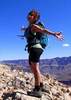
I'm not lookin for a hike persay, yea I know HIKE Az, come on now :)
I'm looking for a lonely place with maybe a nice creek (my car won't make it to Fossil Creek anymore!) and some trees (7 Springs is nice but been there done that too many times!) that is safe for my 3 year old daughter (who can EASILY hike a mile or 2 before whining, yea she's done Vulture Peak!) and our dog (who has hiked out to Skull Cave and back with us and all over the Supes, he's hardcore)

Somewhere beautiful yet simple, with some gentle water to play in, similar to 7 Springs (love the Sears Kay Ruins btw!)maybe some ruins or other cultural or natural history to view...but different...and not more than 2 hours from Phoenix, somewhere we can get to in a passenger car and walk to relatively easily for my girl's sake and needs to be THE perfect getaway on a HOT Arizona day.
...okay, whoever comes up with the perfect getaway for my little family gets to come along!! :D

Ready!? GO! :)
contribute to this member driven resource
ie: RS > Save/Share after hikes Route Scout GPS Topo Mapper on the App Store Route Scout GPS Topo Mapper on Google Play
User avatar
nonot
Guides: 107 | Official Routes: 108
Triplogs Last: 18 d | RS: 0
Water Reports 1Y: 7 | Last: 18 d
Joined: Nov 18 2005 11:52 pm
City, State: Phoenix, AZ

Re: Dog AND Child Friendly Day trips?!

Post by nonot »

Where is the saying Joe posted on this site:

seclusion
short car drive from to Phoenix
near water features

pick any two.

For crowded areas, perhaps somewhere along the Salt River before there are too many tubers?

I think there are a few hikes ssk posted that talk about narrow areas of the Verde river near lake roosevelt. Depends where you are in phoenix though to get there in <2 hrs.
http://hikearizona.com/garmin_maps.php

Hike Arizona it is full of sharp, pointy, ankle-twisting, HAZmaster crushing ROCKS!!
Hike Arizona it is full of sharp, pointy, shin-stabbing, skin-shredding plants!
Hike Arizona it is full of striking, biting, stabbing, venomous wildlife!
contribute to this member driven resource
ie: RS > Save/Share after hikes Route Scout GPS Topo Mapper on the App Store Route Scout GPS Topo Mapper on Google Play
User avatar
kingsnake
Guides: 117 | Official Routes: 114
Triplogs Last: 30 d | RS: 0
Water Reports 1Y: 3 | Last: 95 d
Joined: Dec 20 2010 7:14 am
City, State: Sunnyslope, PHX
Contact:

Re: Dog AND Child Friendly Day trips?!

Post by kingsnake »

Too late. Tubers out in force this afternoon.
http://prestonm.com : Everyone's enjoyment of the outdoors is different and should be equally honored.
contribute to this member driven resource
ie: RS > Save/Share after hikes Route Scout GPS Topo Mapper on the App Store Route Scout GPS Topo Mapper on Google Play
User avatar
Cultjam
Triplogs Last: 5,187 d | RS: 0
Water Reports 1Y: 0 | Last: 5,187 d
Joined: Oct 18 2009 11:55 am
City, State: Phoenix, AZ

Re: Dog AND Child Friendly Day trips?!

Post by Cultjam »

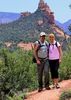
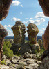
I just posted my trip to Gordon Creek Falls today and it might work for you. It's 1.3 relatively easy miles and offers what girls of all ages love; pretty wildflowers and nice dog tolerant horses (when they're around). It's 25 miles east of Payson off Colcord Road.
contribute to this member driven resource
ie: RS > Save/Share after hikes Route Scout GPS Topo Mapper on the App Store Route Scout GPS Topo Mapper on Google Play
User avatar
joebartels
Guides: 264 | Official Routes: 226
Triplogs Last: 6 d | RS: 1960
Water Reports 1Y: 14 | Last: 9 d
Joined: Nov 20 1996 12:00 pm

Re: Dog AND Child Friendly Day trips?!

Post by joebartels »

@Cultjam
Nice!
I added the listing so others can map directions and estimate their drive.

@HippyHaley
Ellison Creek Cascades is a little closer and perennial :)
Still just over two hours from your listed location. Yet there is no escaping the valley heat with much of a shorter drive. When your daughter gets a little older Christopher Creek Gorge is a fun one.

Lynx Lake Loop Trail is just under two hours. A cool hike around the lake with big pines. However swimming isn't permitted...
- joe
contribute to this member driven resource
ie: RS > Save/Share after hikes Route Scout GPS Topo Mapper on the App Store Route Scout GPS Topo Mapper on Google Play
User avatar
Hippy
Guides: 8 | Official Routes: 1
Triplogs Last: 857 d | RS: 8
Water Reports 1Y: 0 | Last: 1,028 d
Joined: Dec 02 2009 10:08 am
City, State: Grand Canyon
Contact:

Re: Dog AND Child Friendly Day trips?!

Post by Hippy »

@nonot, booo to the Salt :( too many drunks and "dumb kids", there are some lovely picnic areas to get away but theres always someone on the other side of the next tree :( I'll wait on The Salt until my little girl is 10 or so, although we "adults" are having our usual 3rd of July float. whoo! No kiddos for their own safety!! Verde River is amazing...where is there to swim/yak/picnic out near Roosevelt along it??

@cultjam awesome!! that' looks great, we'll have to try that one out next!

@Joe, I LOVE Christopher Creek, my dad use to take me out there all the time when I was younger :)
Is kayaking allowed at Lynx Lake?
I've never heard of Ellison Creek Cascades, gonna have to try that one also! Thanks Joe! (btw Pueblo Canyon Ruins trip this weekend, very excited! :) )

I had this ingenious idea to look up The Verde River, i've always wanted to kayak it! So we discover The Verde River Greenway up in Cottonwood, PERFECT! :y:
Heading up there right now!
contribute to this member driven resource
ie: RS > Save/Share after hikes Route Scout GPS Topo Mapper on the App Store Route Scout GPS Topo Mapper on Google Play
User avatar
paulhubbard
Guides: 7 | Official Routes: 1
Triplogs Last: 514 d | RS: 0
Water Reports 1Y: 0 | Last: 4,172 d
Joined: Jun 01 2010 9:54 am
City, State: Mesa, AZ
Contact:

Re: Dog AND Child Friendly Day trips?!

Post by paulhubbard »

HippyHaley wrote:I've never heard of Ellison Creek Cascades, gonna have to try that one also!
When we went up there last October the the whole area was closed due to a bad fire. Not sure when the fire happened, nor do I know if it's opened back up, but the whole area around the "second crossing" was badly burned and torn up. However, it's still a very pretty drive once past the burn, and you can get to the Christopher Creek area via that road.
Good judgement comes from experience. Experience comes from bad judgement.
contribute to this member driven resource
ie: RS > Save/Share after hikes Route Scout GPS Topo Mapper on the App Store Route Scout GPS Topo Mapper on Google Play
User avatar
chumley
Guides: 94 | Official Routes: 241
Triplogs Last: 6 d | RS: 65
Water Reports 1Y: 78 | Last: 8 d
Joined: Sep 18 2002 8:59 am
City, State: Tempe, AZ

Re: Dog AND Child Friendly Day trips?!

Post by chumley »

Sometimes people will call the area Water Wheel since the campground by the same name is a short ways downstream.

http://hikearizona.com/decoder.php?ZTN=42
http://hikearizona.com/decoder.php?ZTN=141
I'm not sure what my spirit animal is, but I'm confident it has rabies.
contribute to this member driven resource
ie: RS > Save/Share after hikes Route Scout GPS Topo Mapper on the App Store Route Scout GPS Topo Mapper on Google Play
User avatar
chumley
Guides: 94 | Official Routes: 241
Triplogs Last: 6 d | RS: 65
Water Reports 1Y: 78 | Last: 8 d
Joined: Sep 18 2002 8:59 am
City, State: Tempe, AZ

Re: Dog AND Child Friendly Day trips?!

Post by chumley »

Update on the status of the Water Wheel/Ellison Creek Cascades area. Attached is the original area closure order which includes a map. There is no online posting that this order has been rescinded, however I just spoke with the Payson Ranger district on the phone and was told that the area is open to day use only. There is a forest concessionaire in charge of the area and you will have to pay the concessionaire to park. The Tonto Pass is NOT valid for this area. Parking fees must be paid to the concessionaire.

The fire occurred in 2009, so the effects will likely still be quite visible. I haven't been there since it burned, and I haven't seen any photos. Hopefully it will recover quickly.
Attachments
wwclosure.pdf
(374.96 KiB) Downloaded 113 times
I'm not sure what my spirit animal is, but I'm confident it has rabies.
contribute to this member driven resource
ie: RS > Save/Share after hikes Route Scout GPS Topo Mapper on the App Store Route Scout GPS Topo Mapper on Google Play
User avatar
snakemarks
Triplogs Last: 2,808 d | RS: 0
Water Reports 1Y: 0 | Last: 3,473 d
Joined: Oct 31 2007 12:55 pm
City, State: Middle-of-Nowhere, AZ

Re: Dog AND Child Friendly Day trips?!

Post by snakemarks »

@joe bartels
I posted some nice photos from Gordon Creek back in '09 under the title "Gordon Canyon Creek" (I thought 'falls' seemed a bit generous). http://hikearizona.com/photoset.php?ID=8319
Is there some way you could put my photos under your new listing?

P.S. I feel slighted. ;)
I'm at home in the wilderness... it's civilization I have problems with! ](*,)
contribute to this member driven resource
ie: RS > Save/Share after hikes Route Scout GPS Topo Mapper on the App Store Route Scout GPS Topo Mapper on Google Play
User avatar
joebartels
Guides: 264 | Official Routes: 226
Triplogs Last: 6 d | RS: 1960
Water Reports 1Y: 14 | Last: 9 d
Joined: Nov 20 1996 12:00 pm

Re: Dog AND Child Friendly Day trips?!

Post by joebartels »

HippyHaley wrote:Is kayaking allowed at Lynx Lake?
I see the little kayak icon. I remember lots of paddle boats. What makes it nice is motor boats are not allowed. Goldwater Lake is even more quaint, yet it's another half hour of driving.

@paulhubbard good point, I forgot about that fire :(
Was it east or west of Houston Mesa Road or both sides?
- joe
contribute to this member driven resource
ie: RS > Save/Share after hikes Route Scout GPS Topo Mapper on the App Store Route Scout GPS Topo Mapper on Google Play
User avatar
joebartels
Guides: 264 | Official Routes: 226
Triplogs Last: 6 d | RS: 1960
Water Reports 1Y: 14 | Last: 9 d
Joined: Nov 20 1996 12:00 pm

Re: Dog AND Child Friendly Day trips?!

Post by joebartels »

@snakemarks you feel slighted :lol:

Edit photoset name: click the pencil icon right of the state abbreviation
Edit triplog: click "Edit" in lower right corner of triplog
- joe
contribute to this member driven resource
ie: RS > Save/Share after hikes Route Scout GPS Topo Mapper on the App Store Route Scout GPS Topo Mapper on Google Play
User avatar
Cultjam
Triplogs Last: 5,187 d | RS: 0
Water Reports 1Y: 0 | Last: 5,187 d
Joined: Oct 18 2009 11:55 am
City, State: Phoenix, AZ

Re: Dog AND Child Friendly Day trips?!

Post by Cultjam »

snakemarks wrote:@teva joe
I posted some nice photos from Gordon Creek back in '09 under the title "Gordon Canyon Creek" (I thought 'falls' seemed a bit generous). http://hikearizona.com/photoset.php?ID=8319
Is there some way you could put my photos under your new listing?

P.S. I feel slighted. ;)
It is generous to call them falls. :D It's nice to picnic there without being drowned out by the noise.
contribute to this member driven resource
ie: RS > Save/Share after hikes Route Scout GPS Topo Mapper on the App Store Route Scout GPS Topo Mapper on Google Play
User avatar
chumley
Guides: 94 | Official Routes: 241
Triplogs Last: 6 d | RS: 65
Water Reports 1Y: 78 | Last: 8 d
Joined: Sep 18 2002 8:59 am
City, State: Tempe, AZ

Re: Dog AND Child Friendly Day trips?!

Post by chumley »

Cultjam wrote:It is generous to call them falls. :D
Unless I've got the wrong spot, the USGS calls them falls. Though from the picture, I tend to agree with your assessment over some official geological cartographer folks. :)
I'm not sure what my spirit animal is, but I'm confident it has rabies.
contribute to this member driven resource
ie: RS > Save/Share after hikes Route Scout GPS Topo Mapper on the App Store Route Scout GPS Topo Mapper on Google Play
User avatar
joebartels
Guides: 264 | Official Routes: 226
Triplogs Last: 6 d | RS: 1960
Water Reports 1Y: 14 | Last: 9 d
Joined: Nov 20 1996 12:00 pm

Re: Dog AND Child Friendly Day trips?!

Post by joebartels »

joe bartels wrote:Was it east or west of Houston Mesa Road or both sides?
In this topic Dawn posted this perimeter map.
If true, Ellison Creek Cascades wasn't scorched. Anyone know?
- joe
contribute to this member driven resource
ie: RS > Save/Share after hikes Route Scout GPS Topo Mapper on the App Store Route Scout GPS Topo Mapper on Google Play
User avatar
chumley
Guides: 94 | Official Routes: 241
Triplogs Last: 6 d | RS: 65
Water Reports 1Y: 78 | Last: 8 d
Joined: Sep 18 2002 8:59 am
City, State: Tempe, AZ

Re: Dog AND Child Friendly Day trips?!

Post by chumley »

Joe, I can't confirm personally, but that map also lists the acreage at 771, and the final fire size was 773, so it's gotta be pretty accurate. Also the closure order never included the cascades (see my attachment above), just the parking area and part of the access road (420). So I'm quite confident that the area there is still just fine.

See historical information on the Water Wheel fire here: http://www.inciweb.org/incident/1872/
I'm not sure what my spirit animal is, but I'm confident it has rabies.
contribute to this member driven resource
ie: RS > Save/Share after hikes Route Scout GPS Topo Mapper on the App Store Route Scout GPS Topo Mapper on Google Play
User avatar
joebartels
Guides: 264 | Official Routes: 226
Triplogs Last: 6 d | RS: 1960
Water Reports 1Y: 14 | Last: 9 d
Joined: Nov 20 1996 12:00 pm

Re: Dog AND Child Friendly Day trips?!

Post by joebartels »

I converted some GIS files, looks like it's worthy of checking out
http://hikearizona.com/location_g.php?QX=715

The water should be clear
- joe
contribute to this member driven resource
ie: RS > Save/Share after hikes Route Scout GPS Topo Mapper on the App Store Route Scout GPS Topo Mapper on Google Play
User avatar
paulhubbard
Guides: 7 | Official Routes: 1
Triplogs Last: 514 d | RS: 0
Water Reports 1Y: 0 | Last: 4,172 d
Joined: Jun 01 2010 9:54 am
City, State: Mesa, AZ
Contact:

Re: Dog AND Child Friendly Day trips?!

Post by paulhubbard »

joe bartels wrote:Was it east or west of Houston Mesa Road or both sides?
The directions list: "Turn right onto FR420 (at the message board) and follow short 0.2 mile to unmarked Cold Spring Camp Grounds."
It was at this turnoff that the signs were posted everywhere about "Area Closed" and the fire looked to have consumed the forest on both sides of the road.
Good judgement comes from experience. Experience comes from bad judgement.
contribute to this member driven resource
ie: RS > Save/Share after hikes Route Scout GPS Topo Mapper on the App Store Route Scout GPS Topo Mapper on Google Play
User avatar
kevinweitzel75
Triplogs Last: 4,894 d | RS: 0
Water Reports 1Y: 0 | Last: never
Joined: Apr 04 2010 1:15 pm
City, State: Mesa, AZ.

Re: Dog AND Child Friendly Day trips?!

Post by kevinweitzel75 »

@Cultjam
Nice. I think I might head up to Gordon Creek in acouple weeks with my boy. Nice pics. I love the horses.
"Two roads diverged in a wood, and I,
I took the road less traveled by,
And that has made all the difference."
Robert Frost
contribute to this member driven resource
ie: RS > Save/Share after hikes Route Scout GPS Topo Mapper on the App Store Route Scout GPS Topo Mapper on Google Play
User avatar
nonot
Guides: 107 | Official Routes: 108
Triplogs Last: 18 d | RS: 0
Water Reports 1Y: 7 | Last: 18 d
Joined: Nov 18 2005 11:52 pm
City, State: Phoenix, AZ

Re: Dog AND Child Friendly Day trips?!

Post by nonot »

Good ideas, but FYI I don't think you can get there in 2 hrs with the construction.
http://hikearizona.com/garmin_maps.php

Hike Arizona it is full of sharp, pointy, ankle-twisting, HAZmaster crushing ROCKS!!
Hike Arizona it is full of sharp, pointy, shin-stabbing, skin-shredding plants!
Hike Arizona it is full of striking, biting, stabbing, venomous wildlife!
contribute to this member driven resource
ie: RS > Save/Share after hikes Route Scout GPS Topo Mapper on the App Store Route Scout GPS Topo Mapper on Google Play
Post Reply

Return to “General”