 Route Editor

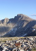
Superstition Mountain Summit
Moderator: HAZ - Moderators
Linked Area, etc none
-
 kgmolsonGuides: 0 | Official Routes: 0Triplogs Last: 6,552 d | RS: 0Water Reports 1Y: 0 | Last: never
 - Joined: Nov 14 2007 6:28 pm
- City, State: Phoenix
Superstition Mountain Summit
What is the best way up to the peak? Via Flatiron or Carney Springs? It seems like this beast is tucked in the middle of the ridgeline...
contribute to this member driven resource
ie: RS > Save/Share after hikes 

-
 rally_toadGuides: 22 | Official Routes: 3Triplogs Last: 1,056 d | RS: 60Water Reports 1Y: 0 | Last: never
 - Joined: May 17 2007 8:06 pm
- City, State: CA
Re: Superstition Mountain Summit
Now I haven't been up there yet. But when I do get the chance I'll probably head up via Hieroglyphic Canyon. It doesnt make sense to get this one from the flatiron unless your doing the entire ridgeline. So either Carney or Hieroglyphic is your best bet.
"Who are you guys??!!" -Farnsworth
contribute to this member driven resource
ie: RS > Save/Share after hikes
-
kgmolsonGuides: 0 | Official Routes: 0Triplogs Last: 6,552 d | RS: 0Water Reports 1Y: 0 | Last: never
- Joined: Nov 14 2007 6:28 pm
- City, State: Phoenix
Re: Superstition Mountain Summit
where is the carney TH? Hieroglyphic Canyon... good call.
contribute to this member driven resource
ie: RS > Save/Share after hikes
-
 wallyfrackGuides: 0 | Official Routes: 6Triplogs Last: 4 d | RS: 0Water Reports 1Y: 2 | Last: 180 d
 - Joined: Mar 11 2003 7:33 pm
- City, State: AZ
Re: Superstition Mountain Summit
Ths Carney TH is down Peralta road on the left about a mile before Peralta TH. The road to the TH is blocked but there is a parking area just off Peralta road. If you see Lost Goldmine TH you've passed it. It's an easier hike than Hieroglyphic canyon. http://hikearizona.com/decoder.php?ZTN=540kgmolson wrote:where is the carney TH?
Last edited by wallyfrack on May 01 2008 3:04 pm, edited 2 times in total.
contribute to this member driven resource
ie: RS > Save/Share after hikes
-
 DarthStillerGuides: 27 | Official Routes: 29Triplogs Last: 3 d | RS: 152Water Reports 1Y: 0 | Last: 4,476 d
 - Joined: Jul 05 2006 12:36 pm
- City, State: Mesa, AZ
Re: Superstition Mountain Summit
It's a kind of a bushwhack up Hieroglyphic Canyon, though. The last time I did it 5 years ago, there were ribbons marking the way. Not too much brush to bust through, but no real trail to speak of until you get to the Ridgeline trail. Some scree here and there, also. I prefer the Carney Springs way myself. maybe a bit longer, but easier if you stay on the trail (shutup, Wally).
contribute to this member driven resource
ie: RS > Save/Share after hikes
-
 joebartelsGuides: 264 | Official Routes: 224Triplogs Last: 2 d | RS: 2064Water Reports 1Y: 28 | Last: 12 d
 - Joined: Nov 20 1996 12:00 pm
Re: Superstition Mountain Summit
If you're looking to do the SE peak 5057 then do the loop, it's paved to the cloudview/hiero TH
http://hikearizona.com/location_g.php?GPS=41
plus there's a good chance to see some rattlers in the lower third of the ascent in either heiro or carney canyons with an early start, definitely go clockwise up hiero
The grunt of the hike is over before it heats up. It was 95 degrees on the return when I did it in September years ago. The seven day forecast is lower than that now. (I think)
- joe
contribute to this member driven resource
ie: RS > Save/Share after hikes
-
kgmolsonGuides: 0 | Official Routes: 0Triplogs Last: 6,552 d | RS: 0Water Reports 1Y: 0 | Last: never
- Joined: Nov 14 2007 6:28 pm
- City, State: Phoenix
Re: Superstition Mountain Summit
Yeah for sure... this is the weekend to do it. Looks to be in the upper 80's to lower 90's which is cooler than last weekend. I really want to hit this peak before the heat. Thanks for the info. I will get that loop plugged into the ol GPS and shouldnt have too may issues.
Thanks guys!
Thanks guys!
contribute to this member driven resource
ie: RS > Save/Share after hikes
-
rally_toadGuides: 22 | Official Routes: 3Triplogs Last: 1,056 d | RS: 60Water Reports 1Y: 0 | Last: never
- Joined: May 17 2007 8:06 pm
- City, State: CA
Re: Superstition Mountain Summit
If your planning on heading up there tomorrow 5/2 I have the day off and was planning on being in the area, as of right now I'm planning on a solo loop combining Whiskey Spring, Red Tank, and Bluff Spring trail. But would gladly change plans to do the Peak 5057 as its been on my list for a while. Let me know if your interested. We could probably carpool and split the gas money.
"Who are you guys??!!" -Farnsworth
contribute to this member driven resource
ie: RS > Save/Share after hikes
-
kgmolsonGuides: 0 | Official Routes: 0Triplogs Last: 6,552 d | RS: 0Water Reports 1Y: 0 | Last: never
- Joined: Nov 14 2007 6:28 pm
- City, State: Phoenix
Re: Superstition Mountain Summit
Hey Rally- Wont be heading up there until Sunday or Monday... Unfortunatly the 2 best days of the weekend I will be working. Any of those days work for ya?
contribute to this member driven resource
ie: RS > Save/Share after hikes
-
rally_toadGuides: 22 | Official Routes: 3Triplogs Last: 1,056 d | RS: 60Water Reports 1Y: 0 | Last: never
- Joined: May 17 2007 8:06 pm
- City, State: CA
Re: Superstition Mountain Summit
The only days I could do it this weekend would be Friday or Saturday. Sunday I'll be in Tucson till afternoon, and Monday I have school and work.
The next time I'd be able to head up there is next saturday.
The next time I'd be able to head up there is next saturday.
"Who are you guys??!!" -Farnsworth
contribute to this member driven resource
ie: RS > Save/Share after hikes
-
kgmolsonGuides: 0 | Official Routes: 0Triplogs Last: 6,552 d | RS: 0Water Reports 1Y: 0 | Last: never
- Joined: Nov 14 2007 6:28 pm
- City, State: Phoenix
Re: Superstition Mountain Summit
Next Saturday might work... I will have to get back to ya.
contribute to this member driven resource
ie: RS > Save/Share after hikes
-
rally_toadGuides: 22 | Official Routes: 3Triplogs Last: 1,056 d | RS: 60Water Reports 1Y: 0 | Last: never
- Joined: May 17 2007 8:06 pm
- City, State: CA
Re: Superstition Mountain Summit
My only condition for that day would be we would have to be back home before 4, because I have to work at 4:30. But I dont think that would be too much of a problem if we started early.
"Who are you guys??!!" -Farnsworth
contribute to this member driven resource
ie: RS > Save/Share after hikes
-
 johnlpGuides: 1 | Official Routes: 5Triplogs Last: 30 d | RS: 2Water Reports 1Y: 0 | Last: 1,970 d
 - Joined: Mar 16 2008 7:12 pm
- City, State: chandler,az
Re: Superstition Mountain Summit
Have fun! This is a great hike, but not an easy one.
“Good people drink good beer.” Hunter S Thompson
contribute to this member driven resource
ie: RS > Save/Share after hikes
-
 mozdzenGuides: 0 | Official Routes: 0Triplogs Last: 2,867 d | RS: 0Water Reports 1Y: 0 | Last: never
 - Joined: Aug 10 2002 6:08 pm
- City, State: Gilbert, AZ
Re: Superstition Mountain Summit
Hi Everyone,
I was trying to find the trailhead up to the superstition mountain summit today and am not sure if I did or not. I parked in the Lost Goldmine Parking lot and took the trail along the fence until I saw a sign on the fence warning that exploring mines was dangerous. It took about 20 mins to get to this point at a moderate pace. As I see from an earlier post, I went too far. But - it looks like the trail from the suggested parking lot intersects the Lost Goldmine trail at some point - and I hope I found it.
After entering the fenced area, it took us straight to the side of a rock face that was very steep. We found a cairn and proceeded left and found a narrow trail. I forgot my GPS and my wife was getting antsy about doing too much bushwacking without it, so we only went on for another half hour. I almost reached what seemed to look like a saddle before turning around. The clouds were hanging low today and I couldn't see much past this saddle.
Was I on the right trail?
Thanks,
Tom
contribute to this member driven resource
ie: RS > Save/Share after hikes
-
 GrasshopperGuides: 48 | Official Routes: 143Triplogs Last: 315 d | RS: 0Water Reports 1Y: 0 | Last: 1,040 d
 - Joined: Dec 28 2006 5:06 pm
- City, State: Scottsdale, AZ
Re: Superstition Mountain Summit
Here are the two recommended and correct GPS hiking tracks via the Carney Spring Trail.. http://hikearizona.com/map.php?QX=1380 (the black line track is from where you started at the Lost Goldmine Park/TH Start, and the red track line is from the recommended hike description.. http://hikearizona.com/decoder.php?ZTN=540 parking area). The brown teardrop is the waypoint coordinates for where you actually cross over the fence and the start of the Carney Spring Trail. It sounds to me like you may have crossed over the fence too soon (at the mine warning sign area) rather than hiking past the correct fence cross-over point?mozdzen wrote:it looks like the trail from the suggested parking lot intersects the Lost Goldmine trail at some point - and I hope I found it.
(Outside.. "there is No Place Like It!!")
contribute to this member driven resource
ie: RS > Save/Share after hikes
-
mozdzenGuides: 0 | Official Routes: 0Triplogs Last: 2,867 d | RS: 0Water Reports 1Y: 0 | Last: never
- Joined: Aug 10 2002 6:08 pm
- City, State: Gilbert, AZ
Re: Superstition Mountain Summit
Most likely. The Fence still had the lower wire or two still intact, so most likely this sure wasn't an official trail.
Thanks for the info!
Tom
Thanks for the info!
Tom
contribute to this member driven resource
ie: RS > Save/Share after hikes
-
mozdzenGuides: 0 | Official Routes: 0Triplogs Last: 2,867 d | RS: 0Water Reports 1Y: 0 | Last: never
- Joined: Aug 10 2002 6:08 pm
- City, State: Gilbert, AZ
Re: Superstition Mountain Summit
Is there any signage at the correct cross over point? Because when we did cross over, there was a trail coming from the south that led me to believe we had met up with it. Which is strange. But I'm 99.99% sure we crossed over too soon because once at the cliffs, we had to travel west quite a way.
Thanks again,
Tom
Thanks again,
Tom
contribute to this member driven resource
ie: RS > Save/Share after hikes
-
 trekkin_geckoGuides: 10 | Official Routes: 45Triplogs Last: 1 d | RS: 292Water Reports 1Y: 0 | Last: 708 d
 - Joined: Nov 17 2008 4:30 pm
- City, State: phoenix, az
contribute to this member driven resource
ie: RS > Save/Share after hikes
-
GrasshopperGuides: 48 | Official Routes: 143Triplogs Last: 315 d | RS: 0Water Reports 1Y: 0 | Last: 1,040 d
- Joined: Dec 28 2006 5:06 pm
- City, State: Scottsdale, AZ
Re: Superstition Mountain Summit
Here is a pic.. http://hikearizona.com/photo.php?ZIP=159606 from a 10/11/10 picset hike that shows what the "hiker pass-through area at the fence line" looks like. You don't actually cross over the fence, but rather pass through it. As this pic shows, there is a small wilderness sign on the fence, but no trail signage since what I am referring too as the Carney Springs Trail is not an "official" signed or numbered trail. I suggest you enter into your GPS receiver the waypoint coordinates of the fence pass through point (ie, click on the the brown teardrop on my previous post), this along with the above linked pic should help eliminate further guessing.mozdzen wrote:Is there any signage at the correct cross over point?
(Outside.. "there is No Place Like It!!")
contribute to this member driven resource
ie: RS > Save/Share after hikes
-
mozdzenGuides: 0 | Official Routes: 0Triplogs Last: 2,867 d | RS: 0Water Reports 1Y: 0 | Last: never
- Joined: Aug 10 2002 6:08 pm
- City, State: Gilbert, AZ
Re: Superstition Mountain Summit
You guys are awesome! Yes - that wasn't what I crossed over. On the otherhand, it was a pretty trail and we did quite a bit of trail clean up. Some moron shot a box of 100 shells and some smaller ammo and just left the empty shells on the ground as well as the box it came in (plus a broken glass beer bottle). We cleaned up most of it, so perhaps good we found the wrong trail. Maybe I should bring some barbed wire with next time and repair the fence. I think they blasted a large saguaro to pieces. That really gets me upset.
Tom
Tom
contribute to this member driven resource
ie: RS > Save/Share after hikes