| |
| Multnomah Falls to Sherrard Point, OR | | -
| 1 label | 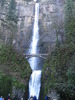 |
|
|
-
-
-
-
-
-
-
-
-
|
| | Multnomah Falls to Sherrard Point, OR | | | |
|
|
Multnomah Falls to Sherrard Point, OR
| | |
|
| Hiking | 16.10 Miles |
4,110 AEG |
| | Hiking | 16.10 Miles | 6 Hrs | | 2.68 mph |
| 4,110 ft AEG | | | | |
|
|
| |
| Linked |
|
none
[ show ]
| no linked trail guides |
| Partners |
|
none
[ show ]
| no partners | | | Beautiful day for a hike in the Gorge. The hike starts at Multnomah Falls which is basically at sea level and goes up to the top of those falls and then continues on to the top of the mountain. No snow on the trail and sunny at the top. Very windy and cold at the top as well. Mt. Hood was easily visible but Mt. Rainier, Mt. Adams, Mt. St. Helens and Mt. Jefferson all were at least partially blocked by clouds. In the summer you can drive to the top but what fun is that? Might be tempted to drive it next time should a clear day present itself. The chance to see all 5 peaks from one location is too good to pass up! |
| _____________________
| | |
|
|
|
|
|
| |
 Route Editor