| |
| Goldfield Ridgeline Loop, AZ | | -
| |  |
|
1 |
-
-
-
-
-
| |  |
|
1 |
|
| | Goldfield Ridgeline Loop, AZ | | | |
|
|
Goldfield Ridgeline Loop, AZ
| | |
|
| Hiking | 3.50 Miles |
1,200 AEG |
| | Hiking | 3.50 Miles | 1 Hour 40 Mns | | 2.10 mph |
| 1,200 ft AEG | | | | |
|
|
| |
| Linked |
|
none
[ show ]
| no linked trail guides |
| Partners |
|
none
[ show ]
| no partners | | I set out on an exploratory hike to examine the potential for a complete ridgeline loop that would originate and finish at Meridian TH. If I had more time this morning (before going to work), then I probably would have just finished this thing off and write it up as an official hike description. That being said, if a hike description already exists for this route, please let me know. I didn't see anything.
I left the trailhead at 5:24am and proceeded up the rocky trail to Bulldog Saddle. This part of the trail is not pleasant. Lots of loose rocks and ankle turning boulders. I've done this trail once before, and decided never again. Now that I've got my sights set on completing a ridgeline hike via this trail, I'm more tolerant about the bumpy approach.
Upon reaching the saddle, I turned East and followed a light foot path, all the while dodging overgrown brush and prickly things on the dirt floor. My goal for this morning was to reach the 3100 foot peak just East of the saddle. I noticed a few cairns and began following them. For most of the way up, the route is pretty well cairned. I stopped along the way to fix a few cairns and added a couple myself.
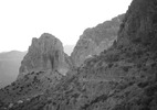
In less than an hour I found myself scrambling up towards the peak across basketball sized boulders. I arrived at the peak which greeted me with views of Four Peaks and Weaver's Needle. I took a few pics and eyed the ridgeline route that I didn't have time to complete on this day. I turned around and headed back down towards Boulder Saddle.
WHAT I PLAN TO COMPLETE AT ANOTHER TIME:
From the initial 3100 foot peak, the ridgeline drops to about 3000 feet and then climbs to its highest point at about 3160. The route continues in a Southeasterly direction and starts to descend before turning right (southwest) down a ridge that leads to a well traveled trail at the base of the mountain. This trail completes the loop back to Meridian TH. Loop is approximately 4.5 miles. |
|
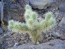
Wildflowers Observation Isolated
|
|
| _____________________
| This is my gym. I have to travel down a bumpy road to get there. There are no treadmillls, no machines, and no personal trainers. I walk..I run..I breathe the fresh air. I can go any time I want, as much as I want and there is no membership fee. |
| | |
|
|
|
|
|
| |
 Route Editor


