| | -
| |  |
|
2 |
-
|
| | |
|
| Hiking | 5.76 Miles |
2,038 AEG |
| | Hiking | 5.76 Miles | 2 Hrs 15 Mns | | 2.56 mph |
| 2,038 ft AEG | | | | |
|
|
| |
| Partners |
|
none
[ show ]
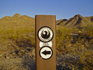
| no partners | | | Looks like the City of Phoenix is starting to name some of the trails in the 620 area. The two I saw today are the Pyramid trail and the Bursera trail. The Pyramid trail starts at the end of Chandler Blvd and goes NE towards the Gila View trail. I didn't go that direction, so I don't know if the Pyramid trail has replaced the Gila View trail/name or if it stays on the desert floor and the Gila View goes up from the intersection of the two trails. The Bursera trail is the new name for the Bees Knees/Gila View West trail as far as I can tell. I didn't hike that way either so I didn't see if there is labeling at the far west end of the trail. I hiked up Lost Mine, down Mine Drop, up Ruins and back. |
| _____________________
| “Good people drink good beer.” Hunter S Thompson |
| | |
|
|
|
|
|
| | |
|
| Hiking | 4.80 Miles |
1,225 AEG |
| | Hiking | 4.80 Miles | 1 Hour 45 Mns | | 2.74 mph |
| 1,225 ft AEG | | | | |
|
|
| |
| Partners |
|
none
[ show ]
| no partners | | | Up Ruins to National, over to Mine Drop and down. |
| _____________________
| “Good people drink good beer.” Hunter S Thompson |
| | |
|
|
|
|
|
| |
 Route Editor


