| | -
-
-
-
-
-
-
| |  |
|
1 |
|
| | |
|
| Canyoneering | 2.70 Miles |
392 AEG |
| | Canyoneering | 2.70 Miles | 1 Hour 13 Mns | | 2.28 mph |
| 392 ft AEG | 2 Mns Break | | | |
|
|
| | |
| Linked |
|
none
[ show ]
| no linked trail guides |
| Partners |
|
none
[ show ]
| no partners | | I had a few hours set aside to hike on Saturday afternoon and I wanted to see if Friday's rains had created some surface flow in Willow Canyon. I think the name "Willow Creek" is just semantics. It's most always a dry canyon. So of course, there was not much surface water after the rain, but there were some small pools.
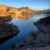
I had hoped to start hiking from the gate to Mormon Flat Dam, but there was a group of people shooting at the ridgeline. This made me really uncomfortable, so I turned around and parked at the intersection of the SRP Dam road and highway 88. I expected to have to bushwhack my way into Willow, but after following a jeep trail I noticed a clear-cut track headed north towards the bottom of the canyon. There were cairns marking this path, once you walk a few hundred meters past the jeep road. This was a pleasant surprise, and made the descent to the wash very quick and easy. This route continues to follow the canyon bottom, skirting the sides of the dry creek bed and crossing it several times. The entire time I heard gunshots from up canyon. This no longer bothered me, but I definitely was paying attention to my surroundings. My goal now was to find a route down to the river. The last 200 meters of Willow descend steeply to the river and there are a few sketchy down climbs. On the HAZ description for this hike, I didn't see any photos taken from the banks of the river. Now I know why. The last few down climbs are very steep, and I decided it wasn't worth the effort. There are great views of the river here, though!
On the return, I spent some considerable time trying to find an alternative route back around the cliff face of the river and hoped to meet up with the SRP road that way. This option quickly cliffs-out, and so then I tried to go up and over. This also proved to be too difficult (maybe if I hadn't sprained my ankle last week on a trail run  ). I ended up walking back up Willow Canyon and exiting up the side canyon that leads directly to the SRP gate on the access road. Thankfully, the target practice party had ended and there was no one in sight. For some reason, I got this idea that I just had to see Mormon Flat Dam, so I walked through the open gate. But just as I passed by the NO TRESPASSING sign, an SRP truck drove around the corner and stopped me. Hmmm. Maybe some time in the future... ). I ended up walking back up Willow Canyon and exiting up the side canyon that leads directly to the SRP gate on the access road. Thankfully, the target practice party had ended and there was no one in sight. For some reason, I got this idea that I just had to see Mormon Flat Dam, so I walked through the open gate. But just as I passed by the NO TRESPASSING sign, an SRP truck drove around the corner and stopped me. Hmmm. Maybe some time in the future...
Willow Canyon is great. And the cairned route is really easy to follow. |
  |
Willow Creek |
Pools to trickle |
Pools to trickle |
| | | Several scattered small pools from recent precip. | | _____________________
| - there's nothing like finding Water in the Desert - |
| | |
|
|
|
|
|
| |
 Route Editor


