| | -
-
-
-
-
| 1 label | 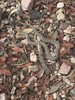 |
|
2 |
-
-
-
|
| | |
|
| Hiking | 10.00 Miles |
3,133 AEG |
| | Hiking | 10.00 Miles | 4 Hrs 24 Mns | | 2.41 mph |
| 3,133 ft AEG | 15 Mns Break | 10 LBS Pack | | |
|
|
| |
| Partners |
|
none
[ show ]
| no partners | | i wanted to do the mccleary/88mac loop using four springs and coming down burnt saddle but the weather forced a change of hand.
pipeline is a jungle
going up four springs reminded me this is probably the best trail in the santa ritas. i saw a twin spotted rattler on the way up
the route out to mccleary is really overgrown and the roughest i have seen it. i did surprisingly see a couple guys up there tho!! not long after i arrived the drizzle started and i knew it was time to bolt. it immediately started coming down harder and confirmed that the rocky and at times slippery ridge out to mccleary is not where you want to be in the rain  
once back on trail i really wanted to continue my loop and actually started it but the rain picked up significantly and then a thunder crack and i was immediately heading back down.
still a great day but could have been super great. |
| _____________________
| | |
|
|
|
|
|
| |
 Route Editor


