| | -
| 1 label | 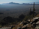 |
|
|
-
| 1 label | 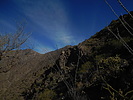 |
|
|
-
-
-
-
-
| 1 label | 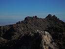 |
|
|
-
| 1 label |  |
|
|
-
| 1 label |  |
|
|
|
| | |
|
| Hiking | 6.41 Miles |
2,515 AEG |
| | Hiking | 6.41 Miles | 5 Hrs 53 Mns | | 1.39 mph |
| 2,515 ft AEG | 1 Hour 17 Mns Break | | | |
|
|
| |
| Linked |
|
none
[ show ]
| no linked trail guides |
| Partners |
|
none
[ show ]
| no partners | | I really enjoyed this hike when I first did it two years ago and decided it was time to go again. Sunny and cool weather in the 60s was perfect for hiking. I hoped to get an earlier start, but lost about 45 minutes following google maps' driving instructions which took me down some "roads" that were barely trails and after getting some new pinstripes on the vehicle I was forced to back track to get to the actual road. Thanks, google 
Anyway, I was glad the weather was cool because it didn't take long before I worked up a sweat on the trail. The rain two days earlier kept the dust down which was nice. There were even a couple small puddles including one on the white rock at the summit. Towards the end it seemed like that white-topped peak just kept moving father away as my legs got more and more tired. My main memory from the first time was the spectacular view from the summit and I forgot the challenge to get there.
After what seemed like forever I eventually got to the summit and it was so totally worth it! Just below the peak the wind was really blowing and it felt cold, but it was calm at the top. Had lunch on the summit and then returned. Still one of my favorite hikes. |
| _____________________
| | |
|
|
|
|
|
| |
 Route Editor


