| |
 | Kinder Crossing - Horse Crossing Loop, AZ | | -
-
-
-
-
| |  |
|
2 |
-
-
-
-
| |  |
|
1 |
-
-
-
-
-
|
| | Kinder Crossing - Horse Crossing Loop, AZ | | | |
|
|
Kinder Crossing - Horse Crossing Loop, AZ
| | |
|
| Hiking | 9.81 Miles |
1,879 AEG |
| | Hiking | 9.81 Miles | 5 Hrs 9 Mns | | 2.60 mph |
| 1,879 ft AEG | 1 Hour 23 Mns Break | 14 LBS Pack | | |
|
|
| |
| Partners |
|
none
[ show ]
| no partners | | I had a route all drawn up to check out the Kinder burn from the Tinder fire and check out some new areas.
At the TH, I realized I never downloaded it to Route Scout.
So plan B
I'd do the the Kinder/Horse Crossing Loop that I'd done quite a while ago... from memory.
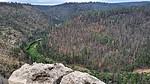
The burn is quite obvious as soon as you hit the TH. If you look to the positive in everything, the fire opened up the views, but there were so many trees burned from a totally needless act.
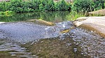
I got to the creek and there were a couple of campsites in use. A hi and a wave returned blank stares.
For the most part there are use trails to follow in the creek bed. I made my way over to the Kinder Crossing East section and made my way up the other side of the canyon. This trail is relatively easy to follow to the top.
From here, It is a couple of FR's to get to the Horse Crossing Trail. There's a sign out by the road that points to where the trail begins, but is is not very obvious. I followed an old 2 track, thinking that was the way to the trail, but when I got close to the rim, it didn't look right. I went off trail to the north until I got to the correct area. It was faint, but I picked up the trail.
Once back in ECC, the trail became more overgrown. I couldn't find the spot to cross to keep my feet dry, so I just plodded across. I made a stop at the pools by the campsite at the bottom of Horse Creek Crossing and then made my way up. The burn here looked to be worse.
Up top and on another FR, I made a call to take a short cut back to the car. I was recording the track I was hiking, so I could see where I started and where I needed to go. But there were no maps on the phone. I knew this wasn't what I was looking to do, when I could see the canyon rim above me across the way. This actually was one of the cool parts of the day. I decided to follow it down and see how far I could get. I made it close to ECC, before hitting a 40' dryfall. It looked like I could have gotten around to the right, but being alone and needing to get back because we had friends coming over to watch the game (damn Suns), I bailed. A steep scurry to the top of the canyon, and I was back to the car. |
|
Wildflowers Observation Light
|
|
| _____________________
There is a very fine line between "hobby" and "mental illness."
Dave Barry  |
| | |
|
|
|
|
|
| |
 Route Editor


