| | -
-
-
-
| |  |
|
1 |
-
-
-
-
-
-
-
-
-
-
-
|
| | |
|
| Hiking | 23.00 Miles |
4,000 AEG |
| | Hiking | 23.00 Miles | 16 Hrs | | 1.44 mph |
| 4,000 ft AEG | | | | |
|
|
| |
| Partners |
|
none
[ show ]
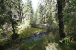
| no partners | | I did the entire Bear Wallow trail in 2 day hikes. Friday September 26, I hiked from the Bear Wallow trailhead for 5.3 miles and on Sunday September 28, I hiked the remaining 3 miles to the Forest Border with the San Carlos Indian Reservation but starting from the Gobbler Point trailhead.
It was my intention to day hike 16 miles roundtrip doing the Bear Wallow trail near Hannagan Meadow. I started early Friday morning from the Bear Wallow trailhead. After 0.9 miles of easy hiking, the deadfall started and never let up. It seems that every 100 or 200 feet of hiking brought another obstacle to get around. That combined with multiple creek crossings wore me out after a little more than 5 miles so I turned around and hiked back out about 3 miles short of my goal which was to hike to the border with the San Carlos Indian reservation.
On Sunday I went back for more. But this time I started from the Gobbler Point trailhead shown on the map shown on the last shot in the picture set.
I thought I might be in for some serious bouts with more deadfall but I was pleasantly surprised. The Gobbler Point trail is very good with great switchbacks to take you down to creek level. After a couple of miles there is some deadfall including a couple of large ones. But they are negotiable and there is far less deadfall than while hiking from the Bear Wallow trailhead. At the end of Gobbler point trail I turned right and hike 0.6 miles to about 0.1 miles onto reservation property. I was looking for a sign and didn't see one but my GPS had the property line on it so I knew I had gone too far. On the way back the Forest Boundary sign appeared nailed to a large pine tree on the side of the tree that you would not see going in unless you turned around. A strange place for it.
Hiking back I went 2.5 extra miles to the place I stopped on Friday so I did manage to hike the entire trail. The 3 miles I did on the Bear Wallow trail had much less deadfall (I would say 20 percent or at least if felt that way) than the 5 miles I did on Friday.
My bottom line is I do not recommend hiking from the Bear Wallow trailhead. I highly recommend hiking from the Gobbler Point trailhead. When you reach the end of the Gobbler Point trail (2.7 miles) you can turn right (to the reservation boundary) or left and hike as much as you want from there before turning around. This is a great hike and I may do it again in 3 weeks to see the fall color. It is mentioned as 1 of 15 fall color hikes in the October 2008 issue of Arizona Highways. |
|
Autumn Foliage Observation Isolated
|
|
| _____________________
| Become a skilled GPS user and it will set you free! |
| | comments disabled by a moderator | |
|
|
|
|
|
| |
 Route Editor


