| |
 | Lookout Mountain Golf Course, AZ | | -
-
-
| 1 label | 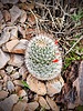 |
|
|
-
-
-
-
-
-
-
-
-
-
|
| | Lookout Mountain Golf Course, AZ | | | |
|
|
Lookout Mountain Golf Course, AZ
| | |
|
| Hiking | 3.59 Miles |
467 AEG |
| | Hiking | 3.59 Miles | 1 Hour 12 Mns | | 3.08 mph |
| 467 ft AEG | 2 Mns Break | | | |
|
|
| |
| Partners |
|
none
[ show ]
| no partners | | I thought with the rain coming I better get another hike in just in case. So I headed to Ireland; I mean Lookout Mountain. It was a nice day and perfect for my hike. I parked below the hill and hiked counterclockwise stopping a few times to take in the course, I mean the landscape. And FYI, my photos from last year are popping up in my google feed and it was like this last year too.
I had to stop for a moment to watch a rabbit make a beeline for whereever it was going; seemed to have a mission. I didn't run into any other hikers after topping out at the first hill on the north side, until heading up the hill on the south side. As I crossed over the southside I took notice of several things including a mountain to the southwest and the deep wash below me. And for some reason the barrel cactus were standing out. I encountered the same older lady that I had seen on my last three hikes here. We must be afternoon hikers.
As I hiked on the east side I had such clear vision to the Superstitions. In fact, I had really clear distant views the entire hike. I can't remember exactly where I noticed they had brushed the trail nicely for a little bit of it and I appreciated that. I crossed through the main trailhead area on the northside and did my little northwestern loop back to Tonto. It was a good hike. As I drove away I saw the same man I've seen the last three times; he was talking on his phone as usual.
WATCH 2:22-3:34PM, 3.47 miles burning 471 calories. 1491-1745 elevation. 130 avg bpm/152 max: 2% Zone 4 Anaerobic (149-167bpm), 41% Zone 3 Aerobic (131-148bpm), 55% Zone 2 Weight Control (112-130bpm). Temperature a lovely 71.5, mostly overcast, slight breeze and 27% humidity (altho it felt more humid than that). |
| _____________________
For me, sometimes it's just as much about the journey as the destination.
Oh, and once in awhile, don't forget to look back at the trail you've traveled. |
| | |
|
|
|
|
|
| |
 Route Editor


