| | -
-
-
-
-
-
-
| 1 label |  |
|
|
-
| 1 label | 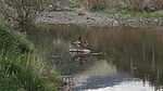 |
|
|
-
| |  |
|
1 |
-
-
| |  |
|
1 |
-
| 1 label | 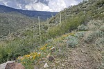 |
|
|
-
-
-
| 1 label | 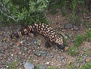 |
|
|
|
| | |
|
| Hiking | 6.78 Miles |
734 AEG |
| | Hiking | 6.78 Miles | 4 Hrs 45 Mns | | 1.70 mph |
| 734 ft AEG | 45 Mns Break | | | |
|
|
| |
| Partners |
|
none
[ show ]
| no partners | | This hike started in the parking lot of the Spur Cross Ranch Conservation Area and was an attempt to follow one of @LosDosSloFolks favorite routes so I used the triplog name he coined for this hike. It was a last-minute change in plan after asking about creek crossing conditions at the toll booth. I didn't have his GPS track on my ancient Garmin Oregon 450 so relied on my memory - always a risky but sometimes rewarding endeavor.
The hike proceeds up the Spur Cross Trail and follows old FS48 along the creek after exiting the park into the Tonto National Forest. The trail crosses the creek 4 times after exiting the park on the way to its intersection with Cave Creek Trail #4 (also marked with an old sign for FS1533). The 4 creek crossings all had strategically placed rocks to enable a dry crossing. At that intersection the track starts a loop, if going counterclockwise, following Trail #4 to an intersection with an old mining road. It then follows that old road north along the east side of Cave Creek Canyon and eventually drops down into the canyon to connect with the trail which follows old FS48 to close the loop and return to Spur Cross. I decided to take the loop in the clockwise direction so proceeded north along the creek on old FS48. After a short distance I came upon an intersection with an old road which starts a steep climb up the east side of the canyon. The ancient topo map in my Garmin shows this road connecting with Trail #4 and the old road used by @LosDosSloFolks.
It was at this point where I decided to explore up this old road to change my loop direction to counter-clockwise. There was an interesting area to explore part way up the trail so I went off-trail to look for evidence of ancient habitation and what appeared from a distance to be a small arch in a rock outcropping part way up the hill. No evidence of the ancients was found and the arch turned out to be the skeleton of a Saguaro which had collapsed against the side of the rock outcropping. After getting back on track I followed the remainder of the loop with excursions to two viewpoints overlooking the canyon. A boulder with a few interesting ancient petroglyphs and some initials scratched in it from more recent times was found on the 2nd viewpoint.
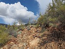
Photo-op highlights of the trek included a standoff with two Javelina who were blocking the trail, A Mallard and his mate perched on a small boulder in a pond-like section of Cave Creek, and a Gila Monster encounter along the Metate Trail. The desert greenery was at its spring-time best with the hillsides covered with green grass and all the desert plants thoroughly enjoying the temporary end of the drought. However it was still a little early for the wildflowers but I did encounter a few patches of Mexican Golden Poppies.
People encounters were few to none after passing into the TNF. However in the Park I encountered a group of horse-back riders following a crusty looking guide who kept his Chiwawa guard dog perched behind him on his horse's back. I mentioned to one of the young ladies trailing behind out of his earshot that only his seeing-eye dog knew where they were going. She replied without smiling, "Yes, I know!" In another attempt at trail humor, I asked two Park trail maintenance employees, who were trailing the horses with shovels in hand, if it was their job to follow the horses and clear the trail of horse poop. One of the two, who looked almost as crusty as the horseback guide, responded loudly "I don't shovel s***!" My attempts at trail humor are possibly an explanation of why most of my hikes are solo. |
|
Wildflowers Observation Isolated
A few patches of Mexican Golden Poppies on south facing hillsides. |
|
| _____________________
| | |
|
|
|
|
|
| |
 Route Editor


