| | -
-
-
| |  |
|
1 |
-
-
-
-
-
-
|
| | |
|
| Hiking | 2.39 Miles |
1,132 AEG |
| | Hiking | 2.39 Miles | 3 Hrs | | 0.86 mph |
| 1,132 ft AEG | 14 Mns Break | | | |
|
|
| |
| Linked |
|
none
[ show ]
| no linked trail guides |
| Partners |
|
[ show ]
| partners | | Note: we did not reach the true high point, turning around on the upper ridge, but I’m still linking to the guide since we did most of the route.
Second hike of the day. Since we had the jeep, we were able to drive almost to the end of the road. Could have gone a few hundred more feet, but we parked at a flat place to turn around. Definitely high clearance 4wd required to drive the last couple of miles. I’m really not sure I would want to do this hike if I had to park farther back and walk the road.
We walked up the road which turned into a faint trail. Steep. Rocky. Slippery.
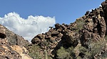
Once over the first saddle, we had to sidehill for a short distance. After that, the tracks we had downloaded generally went to the left of the rock formation in front of us. Instead of doing that, we went up and through it. It was doable, but going left would have been easier.
From there, we followed the ridge up, generally staying below and to the right of the ridgeline. Lots of sidehilling. Steep. Loose. Slippery. Up and up. Sidehilling, grabbing anything we could. Hands and legs full of thorns, needles, etc.
Finally made it up to the upper ridgeline. Up top was more bouldery, which was better. We got to what we hoped was the high point, but determined the actual high point was still almost a quarter-mile away. Looked at our current rate of speed, time of day, work involved, etc, and opted to not continue to the high point. We probably could have made it with enough daylight left, but we weren’t certain of that. I’m not particularly fast on rough offtrail, so I told Bruce since he’s a lot faster, he could go solo to the high point, but he declined.
The descent was not as terrible as we’d feared. We stayed more on the ridgeline, which had more boulders, but was “easier” than the loose sidehilling. It wasn’t necessarily much faster, but was less strenuous. Again, saw a section of lots of alcoves on the way down. Pretty thunderheads to the northeast, which actually gave us some rain while we were driving out later.
Tough hike. If I were to do this one again, I’d want to start early morning to get some shade, and would follow our descent route, which was much better than our ascent. Again, grippy shoes are a necessity. Long pants too. Great day of some desert hikes in some lesser visited areas. |
|
Wildflowers Observation Moderate
|
|
| _____________________
| Stop crying and just go do the hike. |
| | |
|
|
|
|
|
| |
 Route Editor


