| | -
-
| 1 label |  |
|
|
-
-
| 1 label |  |
|
|
-
| 2 labels |  |
|
|
-
-
-
-
| 1 label | 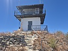 |
|
|
-
| 1 label | 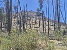 |
|
|
-
-
-
-
| 1 label |  |
|
|
-
|
| | |
|
| Hiking | 1.97 Miles |
443 AEG |
| | Hiking | 1.97 Miles | 55 Mns | | 2.32 mph |
| 443 ft AEG | 4 Mns Break | | | |
|
|
| |
| Linked |
|
none
[ show ]
| no linked trail guides |
| Partners |
|
none
[ show ]
| no partners | | This was a hike to the summit of Eagle Peak in the Gila National Forest. Eagle Peak is a P2K peak and it has a fire lookout on top of it, so what's not to like? It is at an elevation of 9,794 feet and it has prominence of 2,274 feet. Eagle Peak is about 15 miles south of the town of Reserve.
An unpaved road goes all the way to the summit, although the road is gated about a mile from the summit. I drove 15-16 miles from pavement and parked at an open area just below the gate. The first 12 miles or so are on a well graded road that most vehicles could navigate. The road got rougher beyond that, and I was glad that I had a 4WD vehicle. Along the way there was a crossing of the Tularosa River, but the river was only a couple of inches deep so it was not a problem to cross on this day.
From my parking spot it was an easy road walk to the top. The fire lookout at the summit was erected in 1955. It is a 14'X14' cab that sits atop a concrete blockhouse that is 10 feet tall.
There are great views at the summit and I am glad that I stopped to check this peak out. |
| _____________________
| Civilization is a nice place to visit but I wouldn't want to live there |
| | |
|
|
|
|
|
| |
 Route Editor