| |
| Strawberry Mountain via FR 1560, AZ | | -
-
-
-
-
-
-
-
-
-
-
-
| |  |
|
1 |
-
-
-
|
| | Strawberry Mountain via FR 1560, AZ | | | |
|
|
Strawberry Mountain via FR 1560, AZ
| | |
|
| Hiking | 7.50 Miles |
1,225 AEG |
| | Hiking | 7.50 Miles | 4 Hrs 5 Mns | | 1.89 mph |
| 1,225 ft AEG | 7 Mns Break | 10 LBS Pack | | |
|
|
| |
| Partners |
|
[ show ]
| partners | | Seeking a hike in slightly cooler country Tracey scanned back through our history for hikes this time of year and this one popped up from almost exactly 6 years ago, so it was definitely time for a return trip.
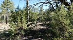
Again, the more direct official route didn't appeal to us so we opted for the same route as last time. While a bit longer, there is practically no need for route-finding. It's as simple as following Forest Road 1560 a mile up to a fence, then hang a left and follow the two-track trail all the way to the summit. While vague at a few points along the way, only a moment or two to look around and one can pick up the route again.
Just over 3/4 mile East of Forest Road 1560 is what appears to be a solar-powered weather station. Google's AI search yielded nothing on my later attempts to locate anything specifics.
At the weather station was a memorial for a Clark C. Baker, 1943-2018, which had a scenic view over Hardscrabble Mesa.
Also at the weather station was a wide dirt road descending steeply to the South, ultimately ending at Forest Road 428A near the Hunt Ranch. Although it peaked my attention slightly, it would just be a descend-and-ascend detour so we skipped it and continued on to the summit.
While stopping to take a drink Tracey saw something moving in thick vegetation by a tree, bigger than a rabbit, so possibly a coyote? I doubted that so I started to walk in a large arc around the area and saw two small birds. When I told Tracey she said it was definitely larger and a moment later I realize it is a wild turkey hen followed by two poults, the small birds I noted moments before. I told Tracey to be ready for a photo while I flushed them out but she wasn't up for a quick-draw of her phone today so the opportunity was missed. Since I had expected (hoped) she would have a clear opportunity, by time I realized she missed the photo it was allI could do to zoom my camera and fire a few shots without time to focus or even know if any bird was in the photo. While the first photo was just a blur, I managed to catch the turkey hen dead-center in the photo, albeit some distance (100'?) away. Oh well, a close look at the photo will reveal only the mother hen as the poults were ahead of her at that moment.
Once in the vicinity of the summit one could wander some distance attempting to find the highest point, but with no knowledge of a summit register, and it not a benchmarked peak we didn't waste any time to find a single highest point, and just continued East to a vantage point overlooking the town of Pine.
From there we decided to follow the Eastern edge of Strawberry Mountain to the Southernmost point before looping back to the NW. Since this part was devoid of any two-track, we simply followed the odd deer/elk trails until reconnecting with the two-track we had followed earlier to the summit.
On the return leg we took the short detour to Maple Spring Tank. Unlike six years ago when the 'pool' of water was about 25 feet in diameter, today it was completely dry.
The name 'Maple Spring Tank' seems more than a bit optimistic... there are no maples, nor is there a spring anywhere within a mile or more.
As we neared the end of Forest Road 1560 where we had parked, a couple in a Chevy Tahoe SUV was driving very slowly up the road. Knowing just how bad it got barely a few hundred yards farther up (first just erosion in the center, then a very rough area with a tall rock 'step'), Tracey and I thought the same thing... they'll be back real soon, IF they can get turned around. As slow as we were walking, sure enough, here they come. As soon as they had returned, they must have turned around before the mild eroded section.
Although we did more wandering than 6 years ago, including slightly more distance and time, somehow we ended up 100+ less AEG.
A few items of note on the drive back to the Valley:
1. From Pine to Payson we were behind two new school buses (likely being delivered somewhere to the South), the drivers of which likely had never driven the route and as such were driving slow, maxing out at 40 mph, even in the '55 mph warning sign' sections. And no, they never used the slow vehicle pull-outs.
(Having stopped for slightly cheaper gas in Payson, we would pass the buses on the climb up to the Ord FR 626 junction)
2. Between Mile 214 & 213 (traveling Southbound) where the lanes are swapped we could see a DPS vehicle with flashing lights in the Northbound lane, followed by a pickup with 'Oversize Load' signs. For a fraction of a second caught sight of a truck & trailer carrying some kind of large cylindrical tank which appeared not to be moving. For the next 1/4 mile due to the terrain we were unable to get a better look at the vehicle, but what we COULD see was a well over a mile of stopped Northbound traffic. As we continued Southward, we saw an unending train of vehicles about to join the standstill. Oh joy!
(And it just so happens as I'm writing this, AZ 87 Beeline is closed Northbound at Bush Highway - Mile 199, for a fire all the way up at Mile 234... about 1.5 miles South of AZ 188.)
As dry as things are, I'm sure we'll have plenty more fun to come this summer... some fun huh? |
| _____________________
| | |
|
|
|
|
|
| |
 Route Editor


