| | -
-
| 1 label | 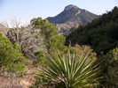 |
|
|
-
-
| 1 label | 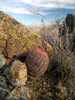 |
|
1 |
-
| 1 label | 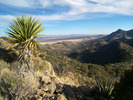 |
|
|
-
| |  |
|
2 |
-
| 1 label | 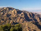 |
|
|
-
| 1 label |  |
|
|
-
-
| |  |
|
1 |
|
| | |
|
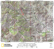
| Hiking | 1.60 Miles |
746 AEG |
| | Hiking | 1.60 Miles | | | |
| 746 ft AEG | | | | |
|
|
| |
| Linked |
|
none
[ show ]
| no linked trail guides |
| Partners |
|
none
[ show ]
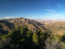
| no partners | | After hiking Black Diamond Peak earlier in the day, I drove up Sorin Camp Road 345A to hike Cochise Peak. The route up was mostly obstacle free, other than having to avoid a catclaw thicket and having to cross a barbed wire fence a few times. Once on top, I was disapointed that I couldn't see the Stronghold, so I made a short walk to the north side of the peak and found the view I was looking for. Upon arriving back at my truck at Sorin Camp, I resumed my journey up FR 345A.
https://www.youtube.com/watch?v=KHTNCKavLMc |
| _____________________
| "…you never know when a hike might break out" -Jim Gaffigan |
| | |
|
|
|
|
|
| |
 Route Editor


