| | -
| 1 label | 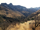 |
|
|
-
-
| 3 labels | 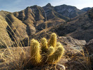 |
|
|
-
| 1 label | 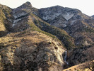 |
|
1 |
-
| 1 label | 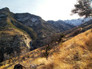 |
|
|
-
| 1 label | 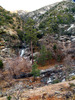 |
|
|
-
| 1 label | 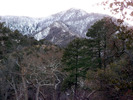 |
|
|
-
| 1 label | 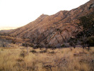 |
|
|
-
| 1 label | 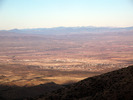 |
|
|
-
| |  |
|
3 |
-
| |  |
|
2 |
-
| |  |
|
1 |
|
| | |
|
| Hiking | 8.31 Miles |
2,486 AEG |
| | Hiking | 8.31 Miles | | | |
| 2,486 ft AEG | | | | |
|
|
| |
| Linked |
|
none
[ show ]
| no linked trail guides |
| Partners |
|
none
[ show ]
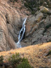
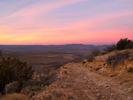
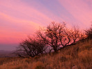
| no partners | | Having been on my "to-do" list for years, I figured I'd better do Deadman. I studied Google satellite photos to determine the way to the trailhead (the Coronado National Forest's info is not helpful at all for that) and set off. I started to drive up FR 6629, but figured it wouldn't take much longer to just hike it due to huge rocks, so I parked and went on foot. Unfortunately, this choice would cut into my time budget. Reaching the trail itself, I had pictured something a bit more well traveled, but thankfully some kind person had made plenty of large cairns to follow through the high, itchy grass. Once on the mountainside, I really began to enjoy this trail, with its views of high, rocky, snow covered country and of course, the waterfall.  Pine trees, water, and a really nice campsite upon my arrival at Deadman Creek made me wish I was backpacking instead of just day hiking. I got within a half mile of the end of the trail before I forced myself to turn around. Daylight was running low, and this is not a trail I would want to try to follow at night. Made it back to my truck just before dark, then made the bumpy ride home. Pine trees, water, and a really nice campsite upon my arrival at Deadman Creek made me wish I was backpacking instead of just day hiking. I got within a half mile of the end of the trail before I forced myself to turn around. Daylight was running low, and this is not a trail I would want to try to follow at night. Made it back to my truck just before dark, then made the bumpy ride home.
https://www.youtube.com/user/PrestonTheY ... Jo1xmesGrg |
| _____________________
| "…you never know when a hike might break out" -Jim Gaffigan |
| | |
|
|
|
|
|
| |
 Route Editor


