| | -
-
| |  |
|
7 |
-
-
-
-
-
| 1 label | 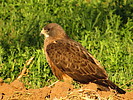 |
|
|
-
-
-
-
-
|
| | |
|
| Hiking | 12.71 Miles |
543 AEG |
| | Hiking | 12.71 Miles | 4 Hrs 1 Min | | 3.16 mph |
| 543 ft AEG | | | | |
|
|
| |
| Linked |
|
none
[ show ]
| no linked trail guides |
| Partners |
|
none
[ show ]
| no partners | | Finally finished this segment of the Maricopa Trail. Looks like I should write up a full description of it.
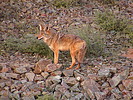
Started from the Horseshoe equestrian park and took that spur to the trail. Right at the junction of the MT, I roused a coyote who looked like he was taking a nap. He got moving but had a very bad limp. He paralleled the wash a little as I hiked it, and then dropped out of sight.
Once I got on the Maricopa Trail, there was the official trail, which was paved and/or concrete, and there was a dirt path lower in the wash mainly for equestrians. I decided to stay on the dirt path. It was nicer to walk along that, and I was away from the foot and bike traffic on the paved path. The dirt path was still maintained very well. It wasn't the typical loose soil and sand in a wash, and the higher grass had recently trimmed down where it crossed through those areas.
Took Sossaman Road north to where I left off, just at the endo of a big subdivision that's currently under construction. There are 2 big farms on the west side of Sossaman with pretty big fields. this section wasn't really interesting other than seeing the farm fields, but it was better than the sidewalks through heavily developed areas. The sun low in the morning provided shade. Saw a hawk sitting in the one field like he was looking for some breakfast to sneak up on.
After getting back to the wash, I headed southbound to the Goldmine TH to finish this section. I missed the turn for Hawes Road at first since I was on the lower dirt path, but I doubled back and got on the road and headed south. This section is primarily walking along the road, on the berm whenever there is one. The last mile the trail/road ascends up to the TH, which gives some nice views to the north of the Supes, 4Peaks, McDowells, etc. Found the Goldmine TH to be closed and headed back to the car.
took a shortcut along Riggs Road on the way back since I had already hiked the MT section in the wash on my way to Sossaman. Finished by 10:30am. |
| _____________________
| | |
|
|
|
|
|
| |
 Route Editor


