| | -
| 1 label | 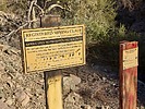 |
|
|
-
-
-
-
| 2 labels | 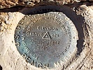 |
|
|
-
-
| 3 labels | 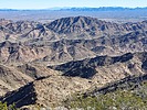 |
|
|
-
| 1 label | 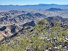 |
|
|
-
| 2 labels | 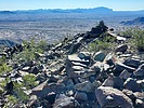 |
|
|
-
| 2 labels | 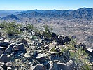 |
|
|
-
| 2 labels | 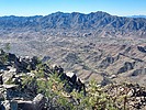 |
|
|
-
-
-
|
| | |
|
| Hiking | 3.36 Miles |
1,252 AEG |
| | Hiking | 3.36 Miles | 3 Hrs 27 Mns | | 1.21 mph |
| 1,252 ft AEG | 41 Mns Break | | | |
|
|
| |
| Linked |
|
none
[ show ]
| no linked trail guides |
| Partners |
|
none
[ show ]
| no partners | | I was on my way to California to do some hiking, and decided to stop in Arizona on the way to bag a peak. The chosen peak this time was Middle Camp Mountain (elevation of 2,527 feet and prominence of 1,287 feet). Middle Camp Mountain is in La Paz County, and is just west of the town of Quartzite, and just north of I-10.
The drive from where I pulled off I-10 to my parking spot was just over 2 miles. It was mostly on a dirt road, but it was a good road and a crossover SUV could have driven to where I parked. I could have driven another 0.7 miles on the road, but it was a rougher 4WD road, but for such a short hike I figured that I would walk the 0.7 miles.
After leaving the road, I went through a couple of drainages that would lead to a ridgeline that is SE of the summit. The first drainage went west, and the second went SW. I was in and out of the drainage some, dodging some palo verde trees and some dry falls. That part went OK, but the last part of the ascent to the ridgeline was very steep and slippery.
Once on the ridgeline, the hike got much better. The ridgeline wasn't real wide, but it was not a knife edge by any means. I mostly was on the top of the ridgeline, but at times I was 10 feet or so to one side of it.
Just before getting to the summit, I looked up and saw a big horn sheep at a false summit, so that was enjoyable.
I got to the summit, which has the benchmark, height of light remnants, and a couple of reference marks. However, I only located one of the reference marks. There are nice, unobstructed 360 degree views, so I hung out there for a bit.
There is another potential highpoint that is about 1,000 feet past the benchmark location. I naturally had to hike over to it. The hike between the 2 competing highpoints was probably the best part of the hike -- great views and nice terrain to hike on. It is hard to say which of the highpoints is highest, as they seem to be within a couple of feet of each other. In other words, it is too close to call, so it's best to tag them both and then you are sure to have hit the highpoint.
I descended the same way that I came up. The descent down from the ridgeline was uncomfortably steep and slippery, so I went slowly on that section. I was going so slow once that Route Scout thought that I was taking a break!
Once past the steepest part the rest of the descent through the drainages went well, since I knew what to expect, having ascended through the drainages earlier. Plus I could look down from an elevated position and pick out a route to take.
I enjoyed this hike, notwithstanding the steep/slippery section just below the ridgeline. |
| _____________________
| Civilization is a nice place to visit but I wouldn't want to live there |
| | |
|
|
|
|
|
| |
 Route Editor


