| | -
| 1 label | 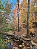 |
|
|
-
-
| |  |
|
1 |
-
| 1 label |  |
|
|
-
| 1 label | 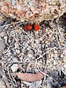 |
|
|
-
-
| 1 label | 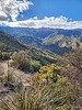 |
|
|
-
-
|
| | |
|
| Hiking | 4.47 Miles |
1,261 AEG |
| | Hiking | 4.47 Miles | 3 Hrs 24 Mns | | 1.71 mph |
| 1,261 ft AEG | 47 Mns Break | | | |
|
|
| |
| Linked |
|
none
[ show ]
| no linked trail guides |
| Partners |
|
none
[ show ]
| no partners | | After Adams Flat on Saturday, I couldn't wait to return and hike the lower portion of Ladybug - something I've never done in almost eight years of hiking on Mt. Graham.
What a great trail! It was so nice that it just kept drawing me up and up, almost to the main part of Veach Ridge before I took a nice break and turned around.
The mountain bike group has done some fantastic work, and even though I don't really ride trails like that - I want to try it now! 
I also enjoyed the Riparian area of Jacobson Creek at the crossing, too. More nice Fall color there.
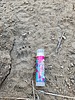
Saw zero people on the trail (on a Monday) - just plenty of bike tire tracks and some footprints ... also a good variety of animal tracks in the soft dirt - some of which were added just in the hour or two between me going up and coming back down. |
|
Autumn Foliage Observation Isolated
|
|
| _____________________
| | |
|
|
|
|
|
| |
 Route Editor


