| | -
-
-
-
-
-
-
-
-
-
-
-
-
-
| 1 label | 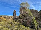 |
|
|
-
|
| | |
|
| Hiking | 10.28 Miles |
1,435 AEG |
| | Hiking | 10.28 Miles | 7 Hrs 36 Mns | | 1.73 mph |
| 1,435 ft AEG | 1 Hour 39 Mns Break | | | |
|
|
| |
| Linked |
|
none
[ show ]
| no linked trail guides |
| Partners |
|
none
[ show ]
| no partners | | With the late arrival of fall this year, I wanted to hit one more riparian area to catch some colors still holding on. I drove through Superior earlier in the week and decided that Arnett Canyon would be a good choice as I could see the colors along Queen Creek still popping.
I arrived at the Picketpost Trailhead a little before sunrise and started out along the L.O.S.T Trail that goes into the canyon. The sunrise was subtle and the temps were very pleasant.
My goal was to hike to Telegraph Canyon and then head back, but go up to the ridgeline area above the canyon via the LOST trail and hike along the edge of the cliffs for the way back. I had looked at the satellite images and saw a couple of old jeep roads that move along the edges. I figured I would just make my own trail after that.
The colors were definitely still popping in the canyon. Such a late turn this year compared to the previous years. Lack of rain, higher temps, it all plays a part, I guess. There were a couple pools and signs of recent running water, but the creek was essentially dry.
I started hiking up a trail/road that I thought would connect to the LOST trail, but it appears I hiked up an older part of Perlite Road. I took this up and around the mine and then made my way to the viewpoints I saw on the satellite images. The views up top did not disappoint. Looking down at this canyon, it gives you a very different perspective from hiking down in the canyon.
The terrain on the top was fairly easy to navigate and I made my way west, along each cliff precipice. The views below changed as I made it from one to the another. I made it towards the end of the higher cliffs and decided to hike down towards the Boyce Thompson Arboretum to see how that’s looking. The colors were nicer in Arnett Canyon.
I made my way back to the cliffs and found a passage to make it back down to the canyon. I hiked back along the route that meets up with the Picketpost/AZT section and then made it back to the trailhead.
I have always enjoyed hiking in this canyon and now that I know how beautiful it is from above, I will be sure to come back again. A nice leisurely 10 miles in an awesome area. The weather was perfect. |
| _____________________
"Jobs fill your pockets, adventures fill your soul."
instagram: @andydilling |
| | |
|
|
|
|
|
| |
 Route Editor


